IMAGES TAKEN NEAR TO
Torness, KIRKWALL, KW15 1UU
Introduction
This page details the photographs taken nearby to Torness, KW15 1UU by members of the Geograph project.
The Geograph project started in 2005 with the aim of publishing, organising and preserving representative images for every square kilometre of Great Britain, Ireland and the Isle of Man.

There are currently over 7.5m images from over14,400 individuals and you can help contribute to the project by visiting https://www.geograph.org.uk
Image Map
Images are licensed for reuse under creativecommons.org/licenses/by-sa/2.0
Notes
- Clicking on the map will re-center to the selected point.
- The higher the marker number, the further away the image location is from the centre of the postcode.
Image Listing (11 Images Found)
Images are licensed for reuse under creativecommons.org/licenses/by-sa/2.0
Image
Details
Distance
1

Papdale valley, east of Kirkwall, Orkney
Public housing and schools in valley, permanent grazing fields in foreground.
Image: © Karl Cooper
Taken: 27 Feb 2006
0.02 miles
2

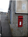
Kirkwall: postbox № KW15 126, The Meadows
A small postbox facing a small parking layby opposite the junction of Marwick Drive. It is emptied finally at 2pm on weekdays and half an hour earlier on Saturdays, and has a drop box (see below) next to it.
Image: © Chris Downer
Taken: 28 Jul 2011
0.06 miles
3
Kirkwall: postbox № KW15 24, Hermaness
This postbox faces Image and is set into the end wall of a line of garages for some of the houses of the estate. The road, seen on the left of the picture, both serves as the garage access and provides parking for visitors to the shop.
The box is emptied at 2:15pm on weekdays and at 1:30pm on Saturdays.
Image: © Chris Downer
Taken: 30 Jul 2011
0.07 miles
4
Approach to Kirkwall from the SW
A new (1980) housing estate getting all the sunshine.
Image: © Stanley Howe
Taken: Unknown
0.07 miles
5

Kirkwall: Papdale Stores
The convenience store is situated inn the centre of the Papdale estate, accessed by paths from several directions and by car from Marwick Drive along a side-road which also serves as garage accesses for some of the neighbouring houses. (See Image)
Image: © Chris Downer
Taken: 30 Jul 2011
0.07 miles
6

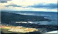
The east end of Kirkwall from the air
Image: © Mike Pennington
Taken: 24 Aug 2018
0.12 miles
7

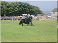
Prize-winning Charolais bull at the County Show
The 133rd County Show, held at Bignold Park.
Image: © Bill Boaden
Taken: 10 Aug 2019
0.19 miles
8
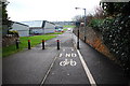
Cycle Lane
The cycle lane ends at the entrance to the grounds of Kirkwall Grammar School.
Image: © Ian Balcombe
Taken: 13 Jan 2009
0.20 miles
9
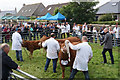
Judging cattle at the Orkney County Show
The 133rd County Show, held at Bignold Park.
Image: © Bill Boaden
Taken: 10 Aug 2019
0.22 miles
10
Bignold Park, Kirkwall - County Show day
Taken at the foot of the Bignold Park, showing a major forest (well, for Orkney, it is) and Kirkwall Bay in the distance. Show takes place on the second Saturday of August every year - this just happened to be decent weather
Image: © Kirsty Smith
Taken: 9 Aug 2003
0.24 miles