IMAGES TAKEN NEAR TO
Craigiefield Road, KIRKWALL, KW15 1UJ
Introduction
This page details the photographs taken nearby to Craigiefield Road, KW15 1UJ by members of the Geograph project.
The Geograph project started in 2005 with the aim of publishing, organising and preserving representative images for every square kilometre of Great Britain, Ireland and the Isle of Man.

There are currently over 7.5m images from over14,400 individuals and you can help contribute to the project by visiting https://www.geograph.org.uk
Image Map
Images are licensed for reuse under creativecommons.org/licenses/by-sa/2.0
Notes
- Clicking on the map will re-center to the selected point.
- The higher the marker number, the further away the image location is from the centre of the postcode.
Image Listing (3 Images Found)
Images are licensed for reuse under creativecommons.org/licenses/by-sa/2.0
Image
Details
Distance
1
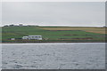
Industrial unit near Craigiefield
As seen from a passing ferry. The unit does not appear to be near anything else.
Image: © Bill Boaden
Taken: 7 Aug 2019
0.20 miles
2

Craigiefield
This large house stands at the south of Craigiefield.
Image: © Rob Burke
Taken: 18 May 2006
0.21 miles
3
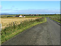
Road junction at HY463119
Turning right at the junction leads to the Head of Work (HY4713); left leads down towards Craigiefield. Land in the extreme distance, left side, is the island of Rousay. Land in the extreme distance, centre and right, is the island of Shapinsay.
Image: © Mark Crook
Taken: 7 Sep 2006
0.24 miles