IMAGES TAKEN NEAR TO
Burnmouth Road, KIRKWALL, KW15 1NU
Introduction
This page details the photographs taken nearby to Burnmouth Road, KW15 1NU by members of the Geograph project.
The Geograph project started in 2005 with the aim of publishing, organising and preserving representative images for every square kilometre of Great Britain, Ireland and the Isle of Man.

There are currently over 7.5m images from over14,400 individuals and you can help contribute to the project by visiting https://www.geograph.org.uk
Image Map
Images are licensed for reuse under creativecommons.org/licenses/by-sa/2.0
Notes
- Clicking on the map will re-center to the selected point.
- The higher the marker number, the further away the image location is from the centre of the postcode.
Image Listing (522 Images Found)
Images are licensed for reuse under creativecommons.org/licenses/by-sa/2.0
Image
Details
Distance
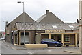
2
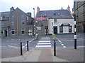
Zebra crossing on Shore Street, Kirkwall
Image: © Nick Mutton 01329 000000
Taken: 19 Aug 2008
0.01 miles
3
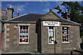
Orkney Wireless Museum, 1 Junction Road, Kirkwall
Category C listed and dated 1866 the close resemblance to the Harbour Master's office in Stromness and its proximity to the harbour hints at its possible original use. Junction Road was constructed in 1865 along with Castle Street in order to open up the approach to the harbour and this was one of the first buildings to go up.
Image: © Jo and Steve Turner
Taken: 8 Jun 2014
0.01 miles
4
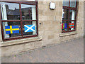
Centre for Nordic Studies, Kirkwall
The Centre for Nordic Studies is located on Kiln Corner in Kirkwall. Displayed in the ground floor windows are the flags of the Nordic countries and regions. Seen here, from left to right, are the flags of Sweden, Scotland, Sami (Lapland) and Orkney.
Image: © Oliver Dixon
Taken: 5 May 2015
0.02 miles
5

Centre for Nordic Studies, Kirkwall
The Centre for Nordic Studies is located on Kiln Corner in Kirkwall. Displayed in the ground floor windows are the flags of the Nordic countries and regions. Seen here, from left to right, are the flags of Norway, Faroe Islands, Finland and Iceland.
Image: © Oliver Dixon
Taken: 5 May 2015
0.02 miles
7
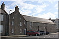
Girnel Keeper's house and Girnel House, 20 and 22 Harbour Street, Kirkwall
The Girnel Keeper's House traditionally with its gabled end to the street is Category B listed of 18th century with a skewputt (stone at the foot of the gable) dated 1643. The Keeper was responsible for administering the intake and distribution of grain, paid in kind as rent to the Earldom estate. See Image for more detail.
Image: © Jo and Steve Turner
Taken: 8 Jun 2014
0.02 miles
8
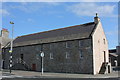
Girnel House, 22 Harbour Street, Kirkwall
18th century store incorporating earlier fabric the Girnal House is Category B listed. The building was used as a storehouse for grain which was paid as rental to the Earldom estate and was kept in 'girnels' or chests. See also Image
Image: © Jo and Steve Turner
Taken: 8 Jun 2014
0.02 miles
9
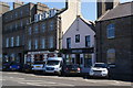
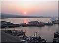
Harbourfront buildings at Kirkwall
Helgi's Bar is a regular entry in the Good Beer Guide.
Image: © Bill Boaden
Taken: 29 Jul 2013
0.03 miles
10
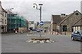
Odin Stone
At the junction of Junction Road and Burnmouth Road, Kirkwall.
Image: © Andrew Abbott
Taken: 26 Aug 2017
0.03 miles