IMAGES TAKEN NEAR TO
Mackenzies Place, KIRKWALL, KW15 1FB
Introduction
This page details the photographs taken nearby to Mackenzies Place, KW15 1FB by members of the Geograph project.
The Geograph project started in 2005 with the aim of publishing, organising and preserving representative images for every square kilometre of Great Britain, Ireland and the Isle of Man.

There are currently over 7.5m images from over14,400 individuals and you can help contribute to the project by visiting https://www.geograph.org.uk
Image Map
Images are licensed for reuse under creativecommons.org/licenses/by-sa/2.0
Notes
- Clicking on the map will re-center to the selected point.
- The higher the marker number, the further away the image location is from the centre of the postcode.
Image Listing (7 Images Found)
Images are licensed for reuse under creativecommons.org/licenses/by-sa/2.0
Image
Details
Distance
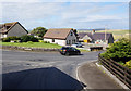
1
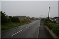
Inganess Road, Kirkwall
Bungalows right on the edge of Kirkwall, seen on a not untypical grey day.
Image: © Bill Boaden
Taken: 1 Aug 2013
0.12 miles
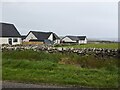
2
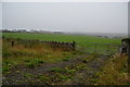
Green fields on the edge of Kirkwall
Viewed on a very grey day. New housing from Kirkwall is slowly spreading this way, as seen far left.
Image: © Bill Boaden
Taken: 1 Aug 2013
0.16 miles
3
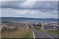
Bignold Park Road
Ready to swoop down, past the County Show, into Kirkwall.
Image: © Richard Webb
Taken: 8 Aug 2015
0.21 miles
5
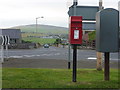
Kirkwall: postbox № KW15 29, Lynn Park
This postbox stands between the main carriageway and a service road of the A961, facing the latter. Behind it, we look down the A963 which is seemingly unnamed. The box is emptied at 2pm on weekdays and at 1:30 on Saturdays.
Image: © Chris Downer
Taken: 25 Jul 2011
0.22 miles
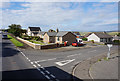
7
Holm Branch Road, Kirkwall
Taken from Holm Road.
Image: © Ian S
Taken: 30 Jul 2018
0.24 miles