IMAGES TAKEN NEAR TO
New Scapa Road, KIRKWALL, KW15 1BL
Introduction
This page details the photographs taken nearby to New Scapa Road, KW15 1BL by members of the Geograph project.
The Geograph project started in 2005 with the aim of publishing, organising and preserving representative images for every square kilometre of Great Britain, Ireland and the Isle of Man.

There are currently over 7.5m images from over14,400 individuals and you can help contribute to the project by visiting https://www.geograph.org.uk
Image Map
Images are licensed for reuse under creativecommons.org/licenses/by-sa/2.0
Notes
- Clicking on the map will re-center to the selected point.
- The higher the marker number, the further away the image location is from the centre of the postcode.
Image Listing (25 Images Found)
Images are licensed for reuse under creativecommons.org/licenses/by-sa/2.0
Image
Details
Distance
1
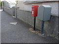
Kirkwall: postbox № KW15 17, Scapa Crescent
A small postbox with drop box alongside (see below), emptied finally at 2pm on weekdays and at 1:30pm on Saturdays.
Image: © Chris Downer
Taken: 28 Jul 2011
0.03 miles
2
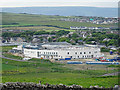
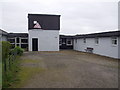
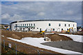
New Hospital
This is the new hospital, currently under construction to replace the Balfour Hospital. Unfortunately with its massive size and white walls it sticks out like a sore thumb from all over the southern part of Mainland and from parts of the South Isles.
Image: © Anne Burgess
Taken: 10 Jun 2018
0.11 miles
3
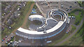
Balfour Hospital
Kirkwall's modern hospital from the air.
Image: © Anne Burgess
Taken: 20 Jun 2023
0.13 miles
5
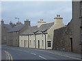
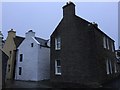
Kirkwall: houses in Wellington Street
An attractive little row of terraced houses at the eastern end of Wellington Street.
Image: © Chris Downer
Taken: 30 Jul 2011
0.19 miles
6
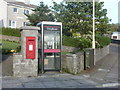
Kirkwall: postbox № KW15 25 and phone, Quoybanks Crescent
An Elizabeth II-reign wall box standing next to a phone box on the corner of Summerdale Drive. It is emptied finally at 2pm on weekdays and half an hour earlier on Saturdays.
Image: © Chris Downer
Taken: 28 Jul 2011
0.19 miles
7
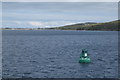
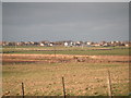
Royal Oak wreck/war grave marker buoy
Shows the relationship of Kirkwall to Scapa Flow and the relative nearness of the U-Boat when it sank one of the RN capital ships in 1939
Image: © Michael Shepherd
Taken: 18 Jul 2012
0.19 miles