IMAGES TAKEN NEAR TO
River Lane, WICK, KW1 4PY
Introduction
This page details the photographs taken nearby to River Lane, KW1 4PY by members of the Geograph project.
The Geograph project started in 2005 with the aim of publishing, organising and preserving representative images for every square kilometre of Great Britain, Ireland and the Isle of Man.

There are currently over 7.5m images from over14,400 individuals and you can help contribute to the project by visiting https://www.geograph.org.uk
Image Map
Images are licensed for reuse under creativecommons.org/licenses/by-sa/2.0
Notes
- Clicking on the map will re-center to the selected point.
- The higher the marker number, the further away the image location is from the centre of the postcode.
Image Listing (202 Images Found)
Images are licensed for reuse under creativecommons.org/licenses/by-sa/2.0
Image
Details
Distance
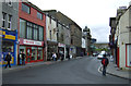
1

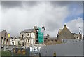
Bridge Street, Wick
The classic - and maybe the best known view of Wick
Image: © C L T Smith
Taken: Unknown
0.02 miles
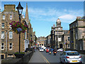
4

Wick - Bridge Street
Close to the Wick River bridge.
Wikipedia : https://en.wikipedia.org/wiki/Wick,_Caithness
River : https://en.wikipedia.org/wiki/Wick_River
Image: © James Emmans
Taken: 17 Sep 2016
0.02 miles
6
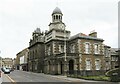
Wick Town Hall
A quite imposing piece of municipal architecture in what was once the county town of Caithness and had more importance and wealth than today. The building is grade 'B' listed, but the part nearest the camera is later than the rest, which dates from 1828.
Image: © Gordon Hatton
Taken: 12 Jun 2021
0.03 miles
7
Consigned to history
Council Offices in Wick being demolished to make way for a new building
Image: © John MacKenzie
Taken: 22 May 2013
0.03 miles
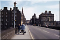
8
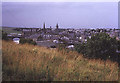
Wick town centre
Looking northwards towards the two church spires with the town bridge on the left.
Image: © Trevor Rickard
Taken: Unknown
0.04 miles
9
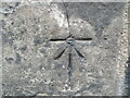
Ordnance Survey Cut Mark with Bolt
This mark and bolt can be found on the roadside wall of a building in Bridge Street, Wick.
The recorded details give a height of 7.0221 metres above sea level.
For more detail see : https://www.bench-marks.org.uk/bm28090
Image: © Peter Wood
Taken: 24 Jun 2022
0.04 miles
10
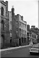
The British Linen Bank, Bridge Street, Wick, 1965
Dated 1935. John Keppie and Henderson, Architects, Glasgow, showing the influence of Charles Rennie Macintosh. Listed Category B. Now a branch of the Royal Bank of Scotland.
Image: © Alan Murray-Rust
Taken: Unknown
0.04 miles