IMAGES TAKEN NEAR TO
Louisburgh Street, WICK, KW1 4NS
Introduction
This page details the photographs taken nearby to Louisburgh Street, KW1 4NS by members of the Geograph project.
The Geograph project started in 2005 with the aim of publishing, organising and preserving representative images for every square kilometre of Great Britain, Ireland and the Isle of Man.

There are currently over 7.5m images from over14,400 individuals and you can help contribute to the project by visiting https://www.geograph.org.uk
Image Map
Images are licensed for reuse under creativecommons.org/licenses/by-sa/2.0
Notes
- Clicking on the map will re-center to the selected point.
- The higher the marker number, the further away the image location is from the centre of the postcode.
Image Listing (149 Images Found)
Images are licensed for reuse under creativecommons.org/licenses/by-sa/2.0
Image
Details
Distance

3
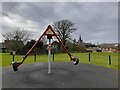
Play Equipment, King George's Field.
A playground within a park dedicated to King George V.
Image: © David Bremner
Taken: 10 Mar 2021
0.06 miles
4

Pair of Elizabethan postboxes, Wick Post Office
On High Street.
Both numbered Postbox No. KW1 27.
Image: © JThomas
Taken: 15 Aug 2016
0.06 miles
5
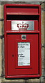
Close up, Elizabethan postbox, Wick Post Office (left)
Postbox No. KW1 27.
Image: © JThomas
Taken: 15 Aug 2016
0.06 miles
6
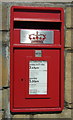
Close up, Elizabethan postbox, Wick Post Office (right)
Postbox No. KW1 27.
Image: © JThomas
Taken: 15 Aug 2016
0.06 miles
7
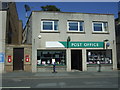
Wick Post Office
On High Street.
Showing position of Elizabethan postboxes, both numbered Postbox No. KW1 27.
Image: © JThomas
Taken: 15 Aug 2016
0.06 miles


