IMAGES TAKEN NEAR TO
Bonaccord Street, WICK, KW1 4JD
Introduction
This page details the photographs taken nearby to Bonaccord Street, KW1 4JD by members of the Geograph project.
The Geograph project started in 2005 with the aim of publishing, organising and preserving representative images for every square kilometre of Great Britain, Ireland and the Isle of Man.

There are currently over 7.5m images from over14,400 individuals and you can help contribute to the project by visiting https://www.geograph.org.uk
Image Map
Images are licensed for reuse under creativecommons.org/licenses/by-sa/2.0
Notes
- Clicking on the map will re-center to the selected point.
- The higher the marker number, the further away the image location is from the centre of the postcode.
Image Listing (26 Images Found)
Images are licensed for reuse under creativecommons.org/licenses/by-sa/2.0
Image
Details
Distance
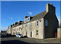
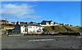
1

Bon Accord Street
These houses that front on to a path are part of Bon Accord Street.
Image: © David Bremner
Taken: 30 Aug 2022
0.03 miles
2
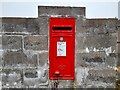
Post Box at Hillhead Road
KW1 22. Royal Mail list this box as 'Hillhead Road'.
Image: © David Bremner
Taken: 12 May 2021
0.04 miles
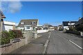
3
New Houses on Willowbank Road
Modern houses on Wick's Willowbank Road. The age of housing increases and the style changes towards the town centre.
Image: © Mary and Angus Hogg
Taken: 25 Oct 2014
0.07 miles
4

Council Houses on Willowbank Road
Council houses on Wick's Willowbank Road. The age of housing increases and the style changes towards the town centre. Modern private houses are found to the west, with older stone-built houses to the east.
Image: © Mary and Angus Hogg
Taken: 25 Oct 2014
0.09 miles
6
Traditional Housing in Willowbank
A block of older houses on Wick's Willowbank Road. The age of housing increases and the style changes towards the town centre. Council houses then modern private houses are found further to the west.
Image: © Mary and Angus Hogg
Taken: 25 Oct 2014
0.16 miles
8
Development Site at Wick Harbour
Development is awaited at this site on the north side of Wick River Basin. The new houses in the background lie in the next square.
Image: © Mary and Angus Hogg
Taken: 25 Oct 2014
0.17 miles
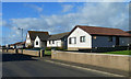
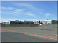
9

Hillhead Primary School
Located on Wick's Willowbank Road.
Image: © Mary and Angus Hogg
Taken: 25 Oct 2014
0.17 miles
10
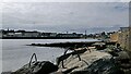
Sea defences, Wick, Caithness
This used to be the site of Baikie's Harbour, one of several small harbours which were on the north bank of the river basin. The OS Name Book of 1871-1873 describes Baikie's Harbour as "a small well built harbour on the north side of Wick Water, used for landing fish".
Image: © Claire Pegrum
Taken: 31 Aug 2020
0.19 miles