IMAGES TAKEN NEAR TO
Crown Square, THURSO, KW14 8ST
Introduction
This page details the photographs taken nearby to Crown Square, KW14 8ST by members of the Geograph project.
The Geograph project started in 2005 with the aim of publishing, organising and preserving representative images for every square kilometre of Great Britain, Ireland and the Isle of Man.

There are currently over 7.5m images from over14,400 individuals and you can help contribute to the project by visiting https://www.geograph.org.uk
Image Map
Images are licensed for reuse under creativecommons.org/licenses/by-sa/2.0
Notes
- Clicking on the map will re-center to the selected point.
- The higher the marker number, the further away the image location is from the centre of the postcode.
Image Listing (9 Images Found)
Images are licensed for reuse under creativecommons.org/licenses/by-sa/2.0
Image
Details
Distance

2

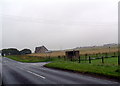
Threshing machine
A sad end for a once valuable threshing machine. It stands at the rear of the disused barn and cottages also shown in this grid square.
Image: © Paul Simonite
Taken: 24 Feb 2010
0.16 miles
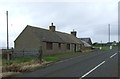
3

Disused barn and cottages
A disused barn and cottages built from local Caithness 'Old Red Sandstone' and roofed with Caithness stone flags.
Image: © Paul Simonite
Taken: 24 Feb 2010
0.16 miles


7

Bus stop and shelter, Murkle
Looking south on the road out to Sibmister.
Image: © JThomas
Taken: 14 Aug 2016
0.21 miles