IMAGES TAKEN NEAR TO
Mansons Lane, THURSO, KW14 8EP
Introduction
This page details the photographs taken nearby to Mansons Lane, KW14 8EP by members of the Geograph project.
The Geograph project started in 2005 with the aim of publishing, organising and preserving representative images for every square kilometre of Great Britain, Ireland and the Isle of Man.

There are currently over 7.5m images from over14,400 individuals and you can help contribute to the project by visiting https://www.geograph.org.uk
Image Map
Images are licensed for reuse under creativecommons.org/licenses/by-sa/2.0
Notes
- Clicking on the map will re-center to the selected point.
- The higher the marker number, the further away the image location is from the centre of the postcode.
Image Listing (188 Images Found)
Images are licensed for reuse under creativecommons.org/licenses/by-sa/2.0
Image
Details
Distance
1
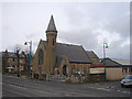
The Scottish Episcopal Church, Thurso
Dedicated to St Peter and the Holy Rood. In Sir George's Street.
Image: © John Lucas
Taken: 28 Nov 2007
0.02 miles
2
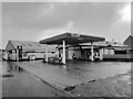
Study of a Caithness Gas Station
Gulf, Mansons Lane, Thurso.
Image: © David Bremner
Taken: 26 Dec 2022
0.03 miles
3
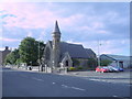
St Peter and the Holy Rood, Thurso
Episcopal Church of Scotland.
Image: © JThomas
Taken: 12 Aug 2016
0.03 miles
4
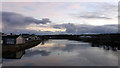
The Thurso River
Viewed from the Thurso Bridge.
Image: © John Lucas
Taken: 23 Nov 2018
0.04 miles
5
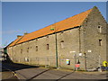
The Old Brewery, Thurso
Likely to be demolished in 2007.
Image: © david glass
Taken: 20 Feb 2007
0.04 miles
6
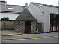
Meadow Well, Thurso
This small building houses the well which was once the main water supply for the town of Thurso.
Image: © Bill Henderson
Taken: 28 Sep 2007
0.04 miles
7
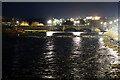
Thurso Bridge
Carries the A9 road across the river. Viewed from the Ellen footbridge.
Image: © John Lucas
Taken: 9 Dec 2021
0.04 miles
8

Iceland Gull, Thurso Riverside
A second-winter bird by the River Thurso.
Image: © David Bremner
Taken: 15 Jan 2022
0.04 miles
9
Thurso: Meadow Well
A helpful notice visible through the window states:
The Meadow Well was for centuries Thurso's main water supply. In 1818 the cistern was enlarged and the casing was completed in 1823 as the date on the finial shows. The present pump was installed around 1850 and was used up to the 1920s to fill water carriers to damp down street dust. The Well was more than a source of water, it was the meeting place for the Townsfolk, for talk and for the exchange of local news.
Image: © Chris Downer
Taken: 23 Oct 2007
0.05 miles
10
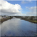
River Thurso looking northwards from A9 bridge
Image: © Robert Eva
Taken: 22 Sep 2018
0.05 miles