IMAGES TAKEN NEAR TO
Murkle View, THURSO, KW14 8DG
Introduction
This page details the photographs taken nearby to Murkle View, KW14 8DG by members of the Geograph project.
The Geograph project started in 2005 with the aim of publishing, organising and preserving representative images for every square kilometre of Great Britain, Ireland and the Isle of Man.

There are currently over 7.5m images from over14,400 individuals and you can help contribute to the project by visiting https://www.geograph.org.uk
Image Map
Images are licensed for reuse under creativecommons.org/licenses/by-sa/2.0
Notes
- Clicking on the map will re-center to the selected point.
- The higher the marker number, the further away the image location is from the centre of the postcode.
Image Listing (14 Images Found)
Images are licensed for reuse under creativecommons.org/licenses/by-sa/2.0
Image
Details
Distance

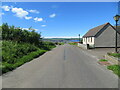
3
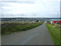
Dropping down towards Thurso
National Cycle Route 1 heading north west.
Image: © JThomas
Taken: 14 Aug 2016
0.11 miles
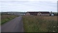
4
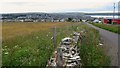
Towards Thurso
A view looking towards Thurso, showing farmland at the town's south eastern edge.
Image: © philip blackwood
Taken: 27 Jul 2015
0.13 miles
5
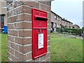
Post Box at Dunnet Road, Thurso
KW14 13D. Royal Mail list this box as 'Dunnet Road'.
Image: © David Bremner
Taken: 5 Aug 2021
0.14 miles
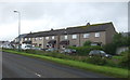
6
Mount Pleasant Road descending towards Thurso
Looking north-westward.
Image: © Peter Wood
Taken: 23 Jun 2022
0.15 miles
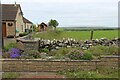
7
Mountpleasant Road
View towards Thurso.
Image: © Richard Webb
Taken: 7 Aug 2015
0.16 miles
10

Bus stop and shelter on the A836, Thurso East
Image: © JThomas
Taken: 14 Aug 2016
0.18 miles