IMAGES TAKEN NEAR TO
Morton Court, THURSO, KW14 8DA
Introduction
This page details the photographs taken nearby to Morton Court, KW14 8DA by members of the Geograph project.
The Geograph project started in 2005 with the aim of publishing, organising and preserving representative images for every square kilometre of Great Britain, Ireland and the Isle of Man.

There are currently over 7.5m images from over14,400 individuals and you can help contribute to the project by visiting https://www.geograph.org.uk
Image Map (Loading...)


Getting Data...Please wait
Leaflet Map data © OpenStreetMap
Images are licensed for reuse under creativecommons.org/licenses/by-sa/2.0
Notes
- Clicking on the map will re-center to the selected point.
- The higher the marker number, the further away the image location is from the centre of the postcode.
Image Listing (112 Images Found)
Images are licensed for reuse under creativecommons.org/licenses/by-sa/2.0
Image
Details
Distance
1

Old St Peter's Kirk, Thurso
The ruins of this church stand close to the harbour. The plaque on the wall by the entrance gate states: "Founded circa 1220 by Gilbert Murray, Bishop of Caithness. Closed to worship 1832."
Image: © Bob Jones
Taken: 9 May 2009
0.00 miles
2
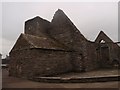
Old St Peter's Kirk, Thurso
The back of Old St Peter's Kirk, Thurso - founded in the 13th century
Image: © Graeme Smith
Taken: 9 Oct 2010
0.02 miles
3
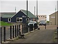
Caf? Tempest
Cafe and other buildings, Thurso Harbour.
Image: © Richard Webb
Taken: 21 Jul 2010
0.02 miles
4
Reflections. Low Tide, Thurso Harbour
Looking towards Riverside from Sir Archibald Road.
Image: © CMackay
Taken: 21 May 2009
0.02 miles
5
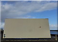
Side wall of pumping station, Thurso
Banksy's "Girl with a Balloon" has turned up here too.
Image: © Robert Eva
Taken: 22 Sep 2018
0.02 miles
6
Thurso Harbour and river mouth
Orkney is on the horizon.
Image: © Alan Reid
Taken: 7 May 2021
0.03 miles
7
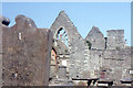
Thurso: ruins of Old St Peter's Kirk
Image: © Christopher Hilton
Taken: 24 May 1992
0.03 miles
8
Boats and Ruins
Boats and Ruins from the harbour road
Image: © Graeme Smith
Taken: 9 Oct 2010
0.04 miles
9

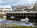
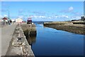
Thurso Harbour
Thurso Harbour consists of this short section of quay, together with a slipway. The quay is on the west bank of the River Thurso. The Harbour is managed by Highland Council.
Image: © Bob Jones
Taken: 9 May 2009
0.04 miles
10

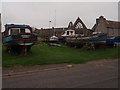
Thurso Harbour entrance
This river port is used by creel vessels and local pleasure craft.
Image: © Bob Jones
Taken: Unknown
0.05 miles