IMAGES TAKEN NEAR TO
Melvich, THURSO, KW14 7YJ
Introduction
This page details the photographs taken nearby to KW14 7YJ by members of the Geograph project.
The Geograph project started in 2005 with the aim of publishing, organising and preserving representative images for every square kilometre of Great Britain, Ireland and the Isle of Man.

There are currently over 7.5m images from over14,400 individuals and you can help contribute to the project by visiting https://www.geograph.org.uk
Image Map
Images are licensed for reuse under creativecommons.org/licenses/by-sa/2.0
Notes
- Clicking on the map will re-center to the selected point.
- The higher the marker number, the further away the image location is from the centre of the postcode.
Image Listing (20 Images Found)
Images are licensed for reuse under creativecommons.org/licenses/by-sa/2.0
Image
Details
Distance
1
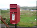
Melvich: postbox № KW14 55
Situated on the main road and serving the south/east part of the village, this postbox is emptied finally (probably only) at 12:45 on weekday and Saturday afternoons. The view behind it is very similar to Image
Image: © Chris Downer
Taken: 25 Jul 2011
0.03 miles
3
Melvich viewed from the road to Bighouse
Image: © John Lucas
Taken: 15 Feb 2017
0.03 miles
4
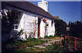
Rowan Bank Cottage in 1992
At this time this tiny cottage with the croft number 52 used to house the village Post Office (since moved to the village shop in Portskerra). The cottage no longer exists.
Image: © Evelyn Simak
Taken: Unknown
0.07 miles
5
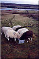
The Post Office Sheep (1995)
The Post Office > Image had its own croft, which was grazed by a small flock of North Country Cheviots. The Post Office sheep were marked with the letters 'PO' in order to distinguish them from the many other sheep in the area. Before the era of marking sheep with a plastic tag (pierced through the animal's ear), each croft used to have their own mark that was either applied onto the sheep's coat or cut into their ears (the latter is called a lug mark). The view is towards Bighouse Lodge and the Halladale river mouth.
Image: © Evelyn Simak
Taken: Unknown
0.10 miles
6
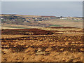
Subdivided strip crofts at Melvich
The strips get narrower as they are passed down the generations
Image: © Alan Reid
Taken: 17 Feb 2013
0.12 miles
7
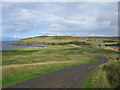
Road to Melvich beach
A view looking east down the lane to the parking area for Melvich beach.
Image: © Phil Williams
Taken: 27 Aug 2006
0.13 miles
8
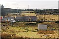
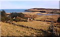
Melvich from across the River Halladale
The view is towards the cottages and the adjacent strips of fields divided by drystone dykes to both sides of the A836, and to the common grazings on the hilltops above.
Image: © Evelyn Simak
Taken: Unknown
0.15 miles
9
Croft in Melvich
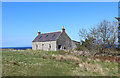
Croft like cottage on the A836 in Melvich
Image: © Chris Heaton
Taken: 16 May 2019
0.15 miles
10
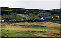
Melvich
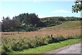
A young shelter belt protects crofts at Melvich, Sutherland.
Image: © Richard Webb
Taken: 7 Aug 2015
0.16 miles