IMAGES TAKEN NEAR TO
Bardnaclavan Place, THURSO, KW14 7XG
Introduction
This page details the photographs taken nearby to Bardnaclavan Place, KW14 7XG by members of the Geograph project.
The Geograph project started in 2005 with the aim of publishing, organising and preserving representative images for every square kilometre of Great Britain, Ireland and the Isle of Man.

There are currently over 7.5m images from over14,400 individuals and you can help contribute to the project by visiting https://www.geograph.org.uk
Image Map (Loading...)


Getting Data...Please wait
Leaflet Map data © OpenStreetMap
Images are licensed for reuse under creativecommons.org/licenses/by-sa/2.0
Notes
- Clicking on the map will re-center to the selected point.
- The higher the marker number, the further away the image location is from the centre of the postcode.
Image Listing (7 Images Found)
Images are licensed for reuse under creativecommons.org/licenses/by-sa/2.0
Image
Details
Distance
1
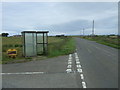
Bus stop and shelter, Bardnaclaven Place
Beside National Cycle Route 1.
Image: © JThomas
Taken: 13 Aug 2016
0.04 miles
2
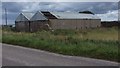
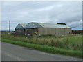
Derelict barn, Bardnaclaven
Recent aerial photographs show the roof to be intact.
Image: © Richard Webb
Taken: 7 Aug 2015
0.06 miles