IMAGES TAKEN NEAR TO
Burnside, THURSO, KW14 7UG
Introduction
This page details the photographs taken nearby to Burnside, KW14 7UG by members of the Geograph project.
The Geograph project started in 2005 with the aim of publishing, organising and preserving representative images for every square kilometre of Great Britain, Ireland and the Isle of Man.

There are currently over 7.5m images from over14,400 individuals and you can help contribute to the project by visiting https://www.geograph.org.uk
Image Map
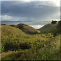
Images are licensed for reuse under creativecommons.org/licenses/by-sa/2.0
Notes
- Clicking on the map will re-center to the selected point.
- The higher the marker number, the further away the image location is from the centre of the postcode.
Image Listing (63 Images Found)
Images are licensed for reuse under creativecommons.org/licenses/by-sa/2.0
Image
Details
Distance
1
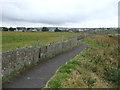
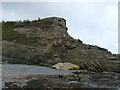
Path down to the rocks
There is a very good path along the clifftop, but there are some unofficial routes off it to the rocky beach. Scrabster harbour is on the other side of the bay.
Image: © Bill Boaden
Taken: 7 Aug 2013
0.04 miles
3
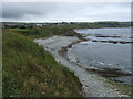
Stream bed to the sea
An un-named stream passes under the A9 to the sea here.
Image: © Robert Eva
Taken: 23 Sep 2018
0.05 miles
5
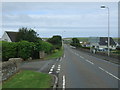
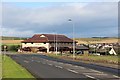
A9, Thurso
Heading north west towards Scrabster.
Image: © JThomas
Taken: 13 Aug 2016
0.07 miles
6
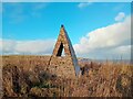
Northland Vent
This sculpture by the late George Wyllie was created for the 2001 Northlands Festival.
The Vent window represents a link between the Icelandic parliament and the Scottish Parliament which determines the sculptures siting.
Image: © David Bremner
Taken: 6 Jan 2024
0.08 miles
7
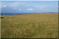
Wild grassland on the edge of Thurso
The open space allows one to see the views from Dunnet Head on the right to Hoy on the left.
Image: © Bill Boaden
Taken: 7 Aug 2013
0.08 miles
8
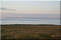
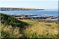
Coastal grassland at Pennyland
The evening light has improved the profile of Hoy across the Pentland Firth.
Image: © Bill Boaden
Taken: 7 Aug 2013
0.09 miles