IMAGES TAKEN NEAR TO
Armadale, THURSO, KW14 7SA
Introduction
This page details the photographs taken nearby to KW14 7SA by members of the Geograph project.
The Geograph project started in 2005 with the aim of publishing, organising and preserving representative images for every square kilometre of Great Britain, Ireland and the Isle of Man.

There are currently over 7.5m images from over14,400 individuals and you can help contribute to the project by visiting https://www.geograph.org.uk
Image Map
Images are licensed for reuse under creativecommons.org/licenses/by-sa/2.0
Notes
- Clicking on the map will re-center to the selected point.
- The higher the marker number, the further away the image location is from the centre of the postcode.
Image Listing (5 Images Found)
Images are licensed for reuse under creativecommons.org/licenses/by-sa/2.0
Image
Details
Distance

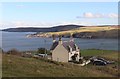
2
New houses at Armadale
A view looking north along the lane through the community of Armadale, showing some new houses at left, built by a housing association.
Image: © Phil Williams
Taken: 27 Aug 2006
0.12 miles
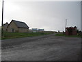
3
Armadale
A view looking south along the lane through the community of Armadale.
Image: © Phil Williams
Taken: 27 Aug 2006
0.13 miles
4
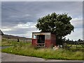
Shack at Armadale
I'm guessing it has been a bus shelter at one time.
Image: © David Bremner
Taken: 12 Aug 2021
0.14 miles