IMAGES TAKEN NEAR TO
Strathy, THURSO, KW14 7RY
Introduction
This page details the photographs taken nearby to KW14 7RY by members of the Geograph project.
The Geograph project started in 2005 with the aim of publishing, organising and preserving representative images for every square kilometre of Great Britain, Ireland and the Isle of Man.

There are currently over 7.5m images from over14,400 individuals and you can help contribute to the project by visiting https://www.geograph.org.uk
Image Map (Loading...)


Getting Data...Please wait
Leaflet Map data © OpenStreetMap
Images are licensed for reuse under creativecommons.org/licenses/by-sa/2.0
Notes
- Clicking on the map will re-center to the selected point.
- The higher the marker number, the further away the image location is from the centre of the postcode.
Image Listing (7 Images Found)
Images are licensed for reuse under creativecommons.org/licenses/by-sa/2.0
Image
Details
Distance
1
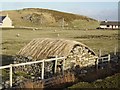
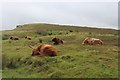
Croft land, Strathy
With distinctive thatched byre. No longer a common sight.
Image: © Richard Webb
Taken: 17 Apr 2006
0.08 miles
2
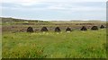
Piles Of Peat
Piles of peat drying close to the Strathy Point road.
Image: © Rude Health
Taken: 23 Aug 2015
0.09 miles
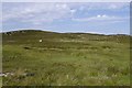
4
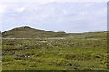
Bog, Strathy
Beside the road to Strathy Point.
Image: © Richard Webb
Taken: 1 Jul 2015
0.10 miles
7
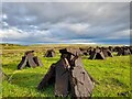
Drying Peats at Strathy
These peats have been cut and set to dry in the wind.
Image: © David Bremner
Taken: 11 Jun 2021
0.23 miles