IMAGES TAKEN NEAR TO
Primrose Avenue, THURSO, KW14 7QX
Introduction
This page details the photographs taken nearby to Primrose Avenue, KW14 7QX by members of the Geograph project.
The Geograph project started in 2005 with the aim of publishing, organising and preserving representative images for every square kilometre of Great Britain, Ireland and the Isle of Man.

There are currently over 7.5m images from over14,400 individuals and you can help contribute to the project by visiting https://www.geograph.org.uk
Image Map
Images are licensed for reuse under creativecommons.org/licenses/by-sa/2.0
Notes
- Clicking on the map will re-center to the selected point.
- The higher the marker number, the further away the image location is from the centre of the postcode.
Image Listing (17 Images Found)
Images are licensed for reuse under creativecommons.org/licenses/by-sa/2.0
Image
Details
Distance
1
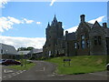
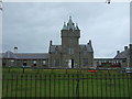
Dunbar Hospital, Thurso
Viewed from the northeast.
Image: © Peter Wood
Taken: 23 Jun 2022
0.13 miles

5
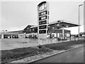
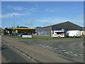
Study of a Caithness Gas Station
JET, Ormlie Road, Thurso.
Image: © David Bremner
Taken: 26 Dec 2022
0.14 miles
6
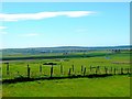
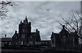
View to Thurso
A view to Thurso from Castletown/Weydale road
Image: © John MacKenzie
Taken: 2 Jun 2011
0.17 miles
8
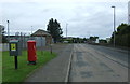
Ormlie Road (B874), Thurso
Showing position of Postbox No. KW14 15.
See Image] for close up
Image: © JThomas
Taken: 13 Aug 2016
0.19 miles
9
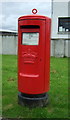
Elizabethan postbox on Ormlie Road, Thurso
Image: © JThomas
Taken: 13 Aug 2016
0.19 miles
10
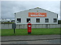
Plumber's merchants, Thurso
Showing position of Postbox No. KW14 15.
See Image] for close up.
Image: © JThomas
Taken: 13 Aug 2016
0.20 miles