IMAGES TAKEN NEAR TO
Robertsons Lane, THURSO, KW14 7DF
Introduction
This page details the photographs taken nearby to Robertsons Lane, KW14 7DF by members of the Geograph project.
The Geograph project started in 2005 with the aim of publishing, organising and preserving representative images for every square kilometre of Great Britain, Ireland and the Isle of Man.

There are currently over 7.5m images from over14,400 individuals and you can help contribute to the project by visiting https://www.geograph.org.uk
Image Map
Images are licensed for reuse under creativecommons.org/licenses/by-sa/2.0
Notes
- Clicking on the map will re-center to the selected point.
- The higher the marker number, the further away the image location is from the centre of the postcode.
Image Listing (175 Images Found)
Images are licensed for reuse under creativecommons.org/licenses/by-sa/2.0
Image
Details
Distance
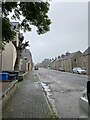
1
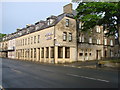
Princess Street, Thurso
Looking towards the town centre from the vicinity of the railway station.
Image: © John Lucas
Taken: 28 Nov 2007
0.07 miles
2
Chalet Veranda
At the Station Hotel, Thurso.
Image: © John Lucas
Taken: 24 Nov 2018
0.07 miles
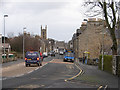
4
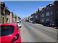
The Pentland Hotel, Princes Street, Thurso
Image: © Bill Henderson
Taken: 15 Jun 2008
0.08 miles
6
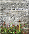
OS Cut Mark: Drill Hall, Sinclair Street
https://www.bench-marks.org.uk/bm193395
Image: © thejackrustles
Taken: 7 Aug 2022
0.08 miles
7
Location of OS Cut Mark: Drill Hall, Sinclair Street
Image: © thejackrustles
Taken: 7 Aug 2022
0.08 miles
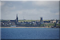
8
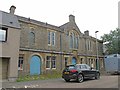
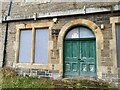
Drill Hall, Thurso
The old Drill Hall in Sinclair Street
Image: © david glass
Taken: 30 Jul 2014
0.08 miles
9
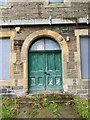
Location of OS Cut Mark: Drill Hall, Sinclair Street
Image: © thejackrustles
Taken: 7 Aug 2022
0.08 miles