IMAGES TAKEN NEAR TO
Sinclair Lane, HALKIRK, KW12 6YF
Introduction
This page details the photographs taken nearby to Sinclair Lane, KW12 6YF by members of the Geograph project.
The Geograph project started in 2005 with the aim of publishing, organising and preserving representative images for every square kilometre of Great Britain, Ireland and the Isle of Man.

There are currently over 7.5m images from over14,400 individuals and you can help contribute to the project by visiting https://www.geograph.org.uk
Image Map (Loading...)


Getting Data...Please wait
Leaflet Map data © OpenStreetMap
Images are licensed for reuse under creativecommons.org/licenses/by-sa/2.0
Notes
- Clicking on the map will re-center to the selected point.
- The higher the marker number, the further away the image location is from the centre of the postcode.
Image Listing (5 Images Found)
Images are licensed for reuse under creativecommons.org/licenses/by-sa/2.0
Image
Details
Distance
1
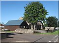
Site of Former Drill Hall
The two adjoined cottages are believed to be the only part of Halkirk Drill Hall to have survived the demolition of the building.
Image: © david glass
Taken: 3 Aug 2014
0.20 miles
2
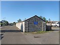
Rifle Range and Site of Former Drill Hall
Halkirk Rifle Range and the site of the former Drill Hall (now demolished). The Rifle Range is still used by the Army Cadet Corps.
Image: © david glass
Taken: 3 Aug 2014
0.22 miles
3
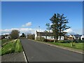
Bridge Street, Halkirk
Bridge Street in the small town of Halkirk, in the far north of Scotland.
Image: © Malc McDonald
Taken: 26 Apr 2023
0.23 miles
4
Fire Hydrant Sign and OS Cut Mark, Corner of Church Street
Fire Hydrant and OS Cut Mark, Halkirk, Junction Bridge Street and Church Street, very hard to spot the cut mark
Image: © thejackrustles
Taken: 3 Aug 2019
0.25 miles
5
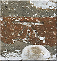
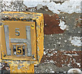
OS Cut Mark: Halkirk, Junction Bridge Street / Church Street
Ordnance Survey Cut Mark: Halkirk, Junction Bridge Street / Church Street
Image: © thejackrustles
Taken: 3 Aug 2019
0.25 miles