IMAGES TAKEN NEAR TO
Sinclair Street, HALKIRK, KW12 6XP
Introduction
This page details the photographs taken nearby to Sinclair Street, KW12 6XP by members of the Geograph project.
The Geograph project started in 2005 with the aim of publishing, organising and preserving representative images for every square kilometre of Great Britain, Ireland and the Isle of Man.

There are currently over 7.5m images from over14,400 individuals and you can help contribute to the project by visiting https://www.geograph.org.uk
Image Map (Loading...)


Getting Data...Please wait
Leaflet Map data © OpenStreetMap
Images are licensed for reuse under creativecommons.org/licenses/by-sa/2.0
Notes
- Clicking on the map will re-center to the selected point.
- The higher the marker number, the further away the image location is from the centre of the postcode.
Image Listing (42 Images Found)
Images are licensed for reuse under creativecommons.org/licenses/by-sa/2.0
Image
Details
Distance
1
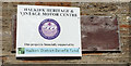
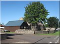
Halkirk, Halkirk Heritage & Vintage Motor Centre, Sinclair Street
Halkirk, Halkirk Heritage & Vintage Motor Centre, Sinclair Street, former plastics factory
Image: © thejackrustles
Taken: 3 Aug 2019
0.06 miles
2
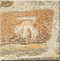
OS Cut Mark: Halkirk, Former Plastics Factory, Sinclair Street
Ordnance Survey Cut Mark: Halkirk, Former Plastics Factory, Sinclair Street, now a Heritage Motor Centre
Image: © thejackrustles
Taken: 3 Aug 2019
0.06 miles
3
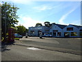
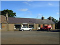
Service station, Halkirk
On Crescent Street.
Image: © JThomas
Taken: 15 Aug 2016
0.10 miles
4
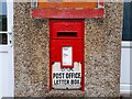
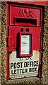
Post Box at Halkirk
A fine wall box from the reign of King George VI.
Image: © David Bremner
Taken: 5 Jul 2021
0.11 miles
5
George VI postbox, Halkirk Post Office
Postbox No. KW12 48.
See Image] for context.
Image: © JThomas
Taken: 15 Aug 2016
0.11 miles
6
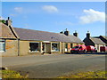
Halkirk Post Office
Showing position of Postbox No. KW12 48.
See Image] for postbox.
Image: © JThomas
Taken: 15 Aug 2016
0.12 miles
8
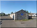
Rifle Range and Site of Former Drill Hall
Halkirk Rifle Range and the site of the former Drill Hall (now demolished). The Rifle Range is still used by the Army Cadet Corps.
Image: © david glass
Taken: 3 Aug 2014
0.12 miles
9
Site of Former Drill Hall
The two adjoined cottages are believed to be the only part of Halkirk Drill Hall to have survived the demolition of the building.
Image: © david glass
Taken: 3 Aug 2014
0.13 miles
10
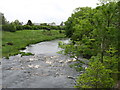
The River Thurso in Halkirk
Looking downstream.
Image: © David Purchase
Taken: 22 Jun 2015
0.14 miles