IMAGES TAKEN NEAR TO
Braal Square, HALKIRK, KW12 6XD
Introduction
This page details the photographs taken nearby to Braal Square, KW12 6XD by members of the Geograph project.
The Geograph project started in 2005 with the aim of publishing, organising and preserving representative images for every square kilometre of Great Britain, Ireland and the Isle of Man.

There are currently over 7.5m images from over14,400 individuals and you can help contribute to the project by visiting https://www.geograph.org.uk
Image Map (Loading...)


Getting Data...Please wait
Leaflet Map data © OpenStreetMap
Images are licensed for reuse under creativecommons.org/licenses/by-sa/2.0
Notes
- Clicking on the map will re-center to the selected point.
- The higher the marker number, the further away the image location is from the centre of the postcode.
Image Listing (9 Images Found)
Images are licensed for reuse under creativecommons.org/licenses/by-sa/2.0
Image
Details
Distance
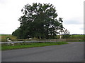
1
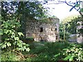
Castle ruin at Braal Castle
This ruined tower is well-hidden among trees and tucked away between other buildings.
Image: © David Martin
Taken: 25 Aug 2010
0.01 miles
4
Braal Castle
A view looking to the northwest across the Sibster Burn towards Braal Castle.
Image: © Phil Williams
Taken: 26 Aug 2006
0.13 miles
5
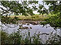
A Glimpse of the River Thurso
Very low levels after this dry summer.
Image: © David Bremner
Taken: 8 Sep 2021
0.18 miles
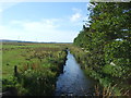
6
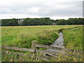
Sibster Burn and waterworks
A view looking south across the bridge carrying the B874 over the Sibster Burn, towards the entrance to the waterworks.
Image: © Phil Williams
Taken: 26 Aug 2006
0.21 miles
7
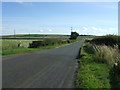
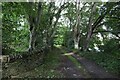
Heading north east from Halkirk
On the B874.
Image: © JThomas
Taken: 15 Aug 2016
0.22 miles
9
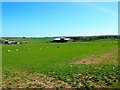
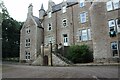
Loch Calder Water Treatment Works
A relatively new works which has replaced original installations.
Image: © John MacKenzie
Taken: 30 Apr 2011
0.23 miles