IMAGES TAKEN NEAR TO
HALKIRK, KW12 6XB
Introduction
This page details the photographs taken nearby to KW12 6XB by members of the Geograph project.
The Geograph project started in 2005 with the aim of publishing, organising and preserving representative images for every square kilometre of Great Britain, Ireland and the Isle of Man.

There are currently over 7.5m images from over14,400 individuals and you can help contribute to the project by visiting https://www.geograph.org.uk
Image Map (12 Images)


Getting Data...Please wait
Leaflet Map data © OpenStreetMap
Images are licensed for reuse under creativecommons.org/licenses/by-sa/2.0
Notes
- Clicking on the map will re-center to the selected point.
- The higher the marker number, the further away the image location is from the centre of the postcode.
Image Listing (12 Images Found)
Images are licensed for reuse under creativecommons.org/licenses/by-sa/2.0
Image
Details
Distance
1
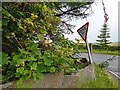
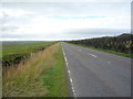
Give Way
Junction of minor road at Sordale with the A9.
Image: © David Bremner
Taken: 5 Aug 2024
0.06 miles
2
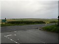
Road Junction
Junction of minor road at Sordale with the A9.
Image: © David Bremner
Taken: 5 Aug 2024
0.06 miles
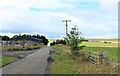
6
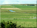
Farmland, Sordale
Distant views towards the River Thurso.
Image: © JThomas
Taken: 12 Aug 2016
0.18 miles
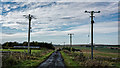
8
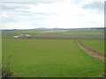
A9, Sordale
Heading north west towards Thurso.
Image: © JThomas
Taken: 12 Aug 2016
0.19 miles
9
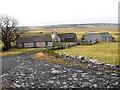
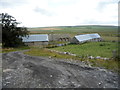
Sordale Steading
Farm steading in ruinous condition
Image: © John MacKenzie
Taken: 7 Feb 2011
0.19 miles
10
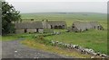
Empty steading, Sordale
Another former farm.
Image: © Richard Webb
Taken: 21 Jul 2010
0.21 miles