IMAGES TAKEN NEAR TO
Leatherhead Road, CHESSINGTON, KT9 2NL
Introduction
This page details the photographs taken nearby to Leatherhead Road, KT9 2NL by members of the Geograph project.
The Geograph project started in 2005 with the aim of publishing, organising and preserving representative images for every square kilometre of Great Britain, Ireland and the Isle of Man.

There are currently over 7.5m images from over14,400 individuals and you can help contribute to the project by visiting https://www.geograph.org.uk
Image Map
Images are licensed for reuse under creativecommons.org/licenses/by-sa/2.0
Notes
- Clicking on the map will re-center to the selected point.
- The higher the marker number, the further away the image location is from the centre of the postcode.
Image Listing (8 Images Found)
Images are licensed for reuse under creativecommons.org/licenses/by-sa/2.0
Image
Details
Distance
1
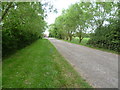
Access road to Byhurst farm
Byhurst Farm is just off Leatherhead Road (A243) at Malden Rushett and supplies horse, pet and poultry products as well as free range eggs. This is the access track leading to the farm.
Image: © Marathon
Taken: 21 May 2014
0.11 miles
2
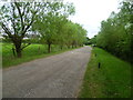
The access road from Byhurst Farm
Byhurst Farm is just off Leatherhead Road (A243) at Malden Rushett and supplies horse, pet and poultry products as well as free range eggs. This is the access track leading back to Leatherhead Road.
Image: © Marathon
Taken: 21 May 2014
0.13 miles
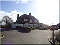
3
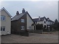
Malden Rushett - Houses on Kingston Road
Victorian semi-detached houses.
Image: © James Emmans
Taken: 18 Aug 2016
0.18 miles
4
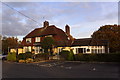
The Shy Horse public house, Malden Rushett
Image: © Mike Pennington
Taken: 17 Nov 2017
0.18 miles
5
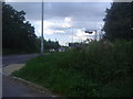
The entrance to Rushett Farm, Chessington
At Leatherhead Road
Image: © David Howard
Taken: 20 Aug 2012
0.22 miles
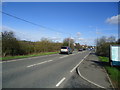
6
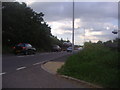
Leatherhead Road at the entrance to Rushett Farm
Image: © David Howard
Taken: 20 Aug 2012
0.22 miles