IMAGES TAKEN NEAR TO
Leatherhead Road, CHESSINGTON, KT9 2NH
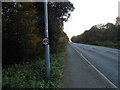
Introduction
This page details the photographs taken nearby to Leatherhead Road, KT9 2NH by members of the Geograph project.
The Geograph project started in 2005 with the aim of publishing, organising and preserving representative images for every square kilometre of Great Britain, Ireland and the Isle of Man.

There are currently over 7.5m images from over14,400 individuals and you can help contribute to the project by visiting https://www.geograph.org.uk
Image Map
Images are licensed for reuse under creativecommons.org/licenses/by-sa/2.0
Notes
- Clicking on the map will re-center to the selected point.
- The higher the marker number, the further away the image location is from the centre of the postcode.
Image Listing (20 Images Found)
Images are licensed for reuse under creativecommons.org/licenses/by-sa/2.0
Image
Details
Distance
1
The entrance to Rushett Farm, Chessington
Image: © David Howard
Taken: 20 Aug 2012
0.02 miles
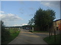
2
Leatherhead Road at the entrance to Rushett Farm
Image: © David Howard
Taken: 20 Aug 2012
0.06 miles
3
The entrance to Rushett Farm, Chessington
At Leatherhead Road
Image: © David Howard
Taken: 20 Aug 2012
0.06 miles
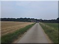
4
Rushett Farm, Chessington
This is still in London due to the shape of the boundary.
Image: © David Howard
Taken: 20 Aug 2012
0.06 miles
5
Leatherhead Road, Malden Rushett
The London Borough of Kingston pokes out into Surrey, Malden Rushett occupies the point surrounded by another county.
Image: © David Howard
Taken: 18 Nov 2012
0.07 miles
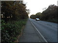
6
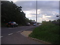
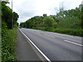
Rushett Common alongside Leatherhead Road
Travelling along the very busy Leatherhead Road, one has the impression that woodland is either side when in fact an agricultural landscape is just beyond the trees on either side. Rushett Common has existed much in its present shape since the beginning of the 19th century, except that it stretched further north than at present towards Hook. The Common is now mostly covered by mature oak woodland.
The First Edition Ordnance Survey Map of 1866 shows Rushett Common with the same boundaries as today but showed that it was mostly rough pasture. The main route from Leatherhead and the Mickleham Gap to Kingston and its market lay along Leatherhead Road. Sheep and cattle would have been driven along it to market, stopping on the way to graze on the pasture of Rushett Common beside the trackway.
This view looks towards Malden Rushett and the traffic lights at the crossroads with the B280.
Image: © Marathon
Taken: 21 May 2014
0.07 miles
7
Access Road from Rushett Farm towards Kingston Road
Image: © James Emmans
Taken: 18 Aug 2016
0.08 miles

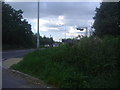
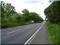
9
Leatherhead Road, Malden Rushett
The stretch of road between Chessington and Leatherhead
Image: © David Howard
Taken: 18 Nov 2012
0.10 miles
10
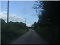
Leatherhead Road, with Rushett Common alongside
Travelling along the very busy Leatherhead Road, one has the impression that woodland is either side when in fact an agricultural landscape is just beyond the trees on either side. Rushett Common has existed much in its present shape since the beginning of the 19th century, except that it stretched further north than at present towards Hook. The Common is now mostly covered by mature oak woodland.
The First Edition Ordnance Survey Map of 1866 shows Rushett Common with the same boundaries as today but showed that it was mostly rough pasture. The main route from Leatherhead and the Mickleham Gap to Kingston and its market lay along Leatherhead Road. Sheep and cattle would have been driven along it to market, stopping on the way to graze on the pasture of Rushett Common beside the trackway.
This view looks towards Leatherhead.
Image: © Marathon
Taken: 21 May 2014
0.12 miles