IMAGES TAKEN NEAR TO
Hurst Lane, EAST MOLESEY, KT8 9EB
Introduction
This page details the photographs taken nearby to Hurst Lane, KT8 9EB by members of the Geograph project.
The Geograph project started in 2005 with the aim of publishing, organising and preserving representative images for every square kilometre of Great Britain, Ireland and the Isle of Man.

There are currently over 7.5m images from over14,400 individuals and you can help contribute to the project by visiting https://www.geograph.org.uk
Image Map
Images are licensed for reuse under creativecommons.org/licenses/by-sa/2.0
Notes
- Clicking on the map will re-center to the selected point.
- The higher the marker number, the further away the image location is from the centre of the postcode.
Image Listing (24 Images Found)
Images are licensed for reuse under creativecommons.org/licenses/by-sa/2.0
Image
Details
Distance
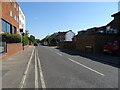
1
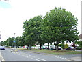
Walton Road, East Molesey
Walton Road, with Abbey Walk running parallel to it behind the line of trees.
Image: © Malc McDonald
Taken: 20 Jun 2010
0.12 miles
2
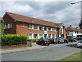
Molesey Clinic, East Molesey
The Molesey Clinic on Abbey Walk, East Molesey.
Image: © Malc McDonald
Taken: 20 Jun 2010
0.13 miles
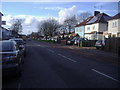
3
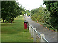
Rear access to houses on Merton Way
Molesey Hurst Recreation Ground is on the left.
Image: © Robin Webster
Taken: 26 Aug 2012
0.14 miles
5

Sign for the Europa, Molesey
See Image] for context.
Image: © JThomas
Taken: 29 Jul 2022
0.14 miles
6
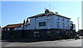
The Europa, Molesey
On Walton Road.
See Image] for sign.
Image: © JThomas
Taken: 29 Jul 2022
0.14 miles
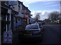
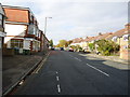
10
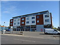
Flats above businesses on Walton Road, Molesey
Image: © JThomas
Taken: 29 Jul 2022
0.15 miles