IMAGES TAKEN NEAR TO
Kings Chase, EAST MOLESEY, KT8 9DG
Introduction
This page details the photographs taken nearby to Kings Chase, KT8 9DG by members of the Geograph project.
The Geograph project started in 2005 with the aim of publishing, organising and preserving representative images for every square kilometre of Great Britain, Ireland and the Isle of Man.

There are currently over 7.5m images from over14,400 individuals and you can help contribute to the project by visiting https://www.geograph.org.uk
Image Map
Images are licensed for reuse under creativecommons.org/licenses/by-sa/2.0
Notes
- Clicking on the map will re-center to the selected point.
- The higher the marker number, the further away the image location is from the centre of the postcode.
Image Listing (26 Images Found)
Images are licensed for reuse under creativecommons.org/licenses/by-sa/2.0
Image
Details
Distance
4
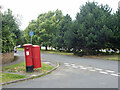
Canted postbox, corner of Merton Way and Park Way
Box KT8 335.
Image: © Robin Webster
Taken: 26 Aug 2012
0.13 miles
7
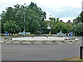
Cyclist artwork, roundabout on A3050 Hurst Road
Image: © Robin Webster
Taken: 26 Aug 2012
0.20 miles
10
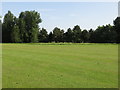
The Thames Path at Hurst Park
At one time there was a racecourse at Hurst Park.
Image: © Eirian Evans
Taken: 13 Oct 2011
0.22 miles