IMAGES TAKEN NEAR TO
Barge Walk, EAST MOLESEY, KT8 9AJ
Introduction
This page details the photographs taken nearby to Barge Walk, KT8 9AJ by members of the Geograph project.
The Geograph project started in 2005 with the aim of publishing, organising and preserving representative images for every square kilometre of Great Britain, Ireland and the Isle of Man.

There are currently over 7.5m images from over14,400 individuals and you can help contribute to the project by visiting https://www.geograph.org.uk
Image Map
Images are licensed for reuse under creativecommons.org/licenses/by-sa/2.0
Notes
- Clicking on the map will re-center to the selected point.
- The higher the marker number, the further away the image location is from the centre of the postcode.
Image Listing (340 Images Found)
Images are licensed for reuse under creativecommons.org/licenses/by-sa/2.0
Image
Details
Distance
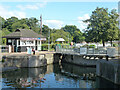
1
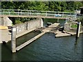
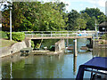
Small boat slipway, Molesey Lock
Quick route for small boats up or down the runners, to bypass the lock.
Image: © Hugh Venables
Taken: 3 Sep 2006
0.00 miles
2
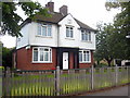
Lock keeper's house at Molesey Lock
The plaque on the gable above the door reads 'Thames Conservancy 1925'.
Image: © Rod Allday
Taken: 23 Jun 2011
0.00 miles
3
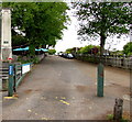
National Cycle Network Route 4, East Molesey
National Cycle Route 4 extends from London to Fishguard, a coastal town in Pembrokeshire, southwest Wales. This part of the route is on the south bank of the River Thames. Molesey War Memorial http://www.geograph.org.uk/photo/5376644 is on the left.
Image: © Jaggery
Taken: 29 Apr 2017
0.00 miles
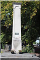
6
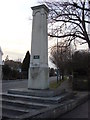
War Memorial, East Molesey
The stone pillar is inscribed with the words "IN MEMORY OF THE MEN OF EAST AND WEST MOLESEY WHO FELL IN THE GREAT WAR 1914 1919" The small plaque adds "ALSO THOSE WHO DIED 1939-45"
Image: © Oxyman
Taken: 14 Feb 2009
0.02 miles
7
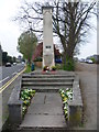
East &West Molesey War Memorial
The inscription facing says "IN MEMORY OF THE MEN OF EAST & WEST MOLESEY WHO FELL IN THE GREAT WAR 1914 - 1919". The small plaque underneath says "ALSO THOSE WHO DIED 1939 - 1945". Hurst Road is on the left here and the Barge Walk, which is the Thames towpath upriver of Hampton Court Bridge, is on the right. The war memorial is actually located in East Molesey, presumably as the setting is more prominent.
Image: © Marathon
Taken: 2 Apr 2014
0.02 miles
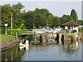
9
Boat rollers, Molesey Lock, River Thames
The pass on the left does not appear to have rollers now.
Image: © Robin Webster
Taken: 26 Aug 2012
0.02 miles
10
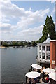
River Thames
View upstream from Hampton Court Bridge
Image: © John Myers
Taken: 4 Jun 2011
0.02 miles