IMAGES TAKEN NEAR TO
Down Street, WEST MOLESEY, KT8 2TG
Introduction
This page details the photographs taken nearby to Down Street, KT8 2TG by members of the Geograph project.
The Geograph project started in 2005 with the aim of publishing, organising and preserving representative images for every square kilometre of Great Britain, Ireland and the Isle of Man.

There are currently over 7.5m images from over14,400 individuals and you can help contribute to the project by visiting https://www.geograph.org.uk
Image Map
Images are licensed for reuse under creativecommons.org/licenses/by-sa/2.0
Notes
- Clicking on the map will re-center to the selected point.
- The higher the marker number, the further away the image location is from the centre of the postcode.
Image Listing (29 Images Found)
Images are licensed for reuse under creativecommons.org/licenses/by-sa/2.0
Image
Details
Distance
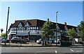
2
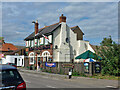
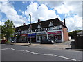
The Cannon, West Molesey
On High Street.
Image: © Robin Webster
Taken: 26 Aug 2012
0.15 miles
4
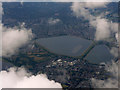
Queen Elizabeth Reservoir from the air
Molesy Park is in the foreground. Viewed from a flight from Glasgow to Heathrow.
Image: © Thomas Nugent
Taken: 10 Aug 2016
0.15 miles
6
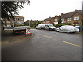
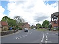
High Street, West Molesey
At the entrance to the local cottage hospital.
Image: © David Howard
Taken: 30 Jun 2014
0.17 miles
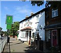
8
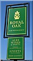
Sign for the Royal Oak, Molesey
See Image] for context.
Image: © JThomas
Taken: 29 Jul 2022
0.18 miles
10
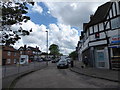
Junction of Walton Road and the High Street
Image: © Basher Eyre
Taken: 25 Apr 2019
0.18 miles