IMAGES TAKEN NEAR TO
Nightingale Road, WEST MOLESEY, KT8 2PQ
Introduction
This page details the photographs taken nearby to Nightingale Road, KT8 2PQ by members of the Geograph project.
The Geograph project started in 2005 with the aim of publishing, organising and preserving representative images for every square kilometre of Great Britain, Ireland and the Isle of Man.

There are currently over 7.5m images from over14,400 individuals and you can help contribute to the project by visiting https://www.geograph.org.uk
Image Map
Images are licensed for reuse under creativecommons.org/licenses/by-sa/2.0
Notes
- Clicking on the map will re-center to the selected point.
- The higher the marker number, the further away the image location is from the centre of the postcode.
Image Listing (32 Images Found)
Images are licensed for reuse under creativecommons.org/licenses/by-sa/2.0
Image
Details
Distance
3
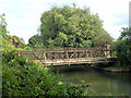
Bridge over River Mole
Although only used as a footbridge, it could really do with a coat or two of paint quite soon. It leads to Nielson Playing Field on the right.
Image: © Robin Webster
Taken: 26 Aug 2012
0.13 miles
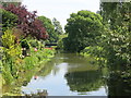
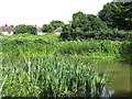
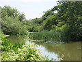
5

The River Mole south of Molesey Park Road
Image: © Mike Quinn
Taken: 6 Jun 2018
0.15 miles
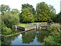
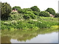
7
The River Mole south of Molesey Park Road (2)
Image: © Mike Quinn
Taken: 6 Jun 2018
0.16 miles
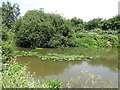
8
The River Mole south of Molesey Park Road (3)
Image: © Mike Quinn
Taken: 6 Jun 2018
0.17 miles
9
The River Mole south of Molesey Park Road (4)
Image: © Mike Quinn
Taken: 6 Jun 2018
0.18 miles
10
The River Mole south of Molesey Park Road (5)
Image: © Mike Quinn
Taken: 6 Jun 2018
0.18 miles