IMAGES TAKEN NEAR TO
Victoria Avenue, WEST MOLESEY, KT8 1SG
Introduction
This page details the photographs taken nearby to Victoria Avenue, KT8 1SG by members of the Geograph project.
The Geograph project started in 2005 with the aim of publishing, organising and preserving representative images for every square kilometre of Great Britain, Ireland and the Isle of Man.

There are currently over 7.5m images from over14,400 individuals and you can help contribute to the project by visiting https://www.geograph.org.uk
Image Map
Images are licensed for reuse under creativecommons.org/licenses/by-sa/2.0
Notes
- Clicking on the map will re-center to the selected point.
- The higher the marker number, the further away the image location is from the centre of the postcode.
Image Listing (50 Images Found)
Images are licensed for reuse under creativecommons.org/licenses/by-sa/2.0
Image
Details
Distance
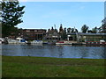
5
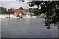
River Thames near Hampton
View over the River Thames near Hampton.
Image: © Philip Halling
Taken: 3 Sep 2011
0.10 miles
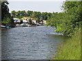
6
Platts Eyot
Island in the Thames at Molesey
Image: © Paul Gillett
Taken: 5 Aug 2013
0.10 miles
7
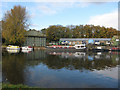
Platt's Eyot
The buildings industrial units and moorings are run by Port Hampton Ltd.
Image: © Hugh Venables
Taken: 6 Nov 2010
0.11 miles
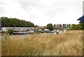
10
Boatyard at Hampton
View to the Hampton side of the river from the Thames Path.
Image: © Eirian Evans
Taken: 13 Oct 2011
0.12 miles