IMAGES TAKEN NEAR TO
Southfields, EAST MOLESEY, KT8 0BP
Introduction
This page details the photographs taken nearby to Southfields, KT8 0BP by members of the Geograph project.
The Geograph project started in 2005 with the aim of publishing, organising and preserving representative images for every square kilometre of Great Britain, Ireland and the Isle of Man.

There are currently over 7.5m images from over14,400 individuals and you can help contribute to the project by visiting https://www.geograph.org.uk
Image Map (Loading...)


Getting Data...Please wait
Leaflet Map data © OpenStreetMap
Images are licensed for reuse under creativecommons.org/licenses/by-sa/2.0
Notes
- Clicking on the map will re-center to the selected point.
- The higher the marker number, the further away the image location is from the centre of the postcode.
Image Listing (26 Images Found)
Images are licensed for reuse under creativecommons.org/licenses/by-sa/2.0
Image
Details
Distance
1
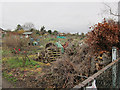
Hampton Court Way allotments
There was a notice on the gate requesting objections to a planned mobile phone mast.
Image: © Hugh Venables
Taken: 31 Dec 2011
0.09 miles

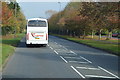
8
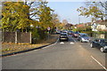
B364 Road
The B364 is a short road in Thames Ditton in north Surrey. It runs 1 mile from Portsmouth Rd to Ember Lane.
Image: © N Chadwick
Taken: 2 Nov 2017
0.12 miles