1
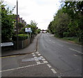
Road bridge over the River Ember, East Molesey
The bridge carries the B3379 Esher Road over the River Ember. http://www.geograph.org.uk/photo/5371782
Image: © Jaggery
Taken: 29 Apr 2017
0.05 miles
2
Esher Road between two rivers, East Molesey
The B3379 Esher Road ahead is between the River Mole a few metres behind the camera
and the River Ember about 100 metres ahead. The Summer Road junction is on the left.
Image: © Jaggery
Taken: 29 Apr 2017
0.07 miles
3
River Ember seen from Esher Road
The River Mole splits in two upriver of Island Barn Reservoir to then merge at East Molesey, just upriver from the bridge carrying Hampton Court Way. The larger channel is called the River Ember. The joined rivers then flow for another 400 metres before joining the River Thames at the eastern end of East Molesey, opposite Hampton Court Palace. This is the channel of the River Ember looking upriver, seen from Esher Road. The bridge crossing the narrower, but more natural, River Mole is about 50 metres to the north.
Image: © Marathon
Taken: 2 Apr 2014
0.07 miles
4
River Ember, East Molesey
The Esher Road crosses two rivers within just over 100 metres; see also
Image
Image: © Derek Harper
Taken: 29 May 2016
0.08 miles
5
Hampton Court Avenue, East Molesey
A cul-de-sac seen from its junction with the Esher Road.
Image: © Derek Harper
Taken: 29 May 2016
0.08 miles
6
River Ember, East Molesey
Downstream along the Ember from the Esher Road bridge.
Out of shot ahead, the Ember flows into the River Mole about 650 metres from the camera.
About 300 metres east of the confluence, the combined rivers flow into the River Thames.
Image: © Jaggery
Taken: 29 Apr 2017
0.08 miles
7
River Ember looking downstream
From the Esher Road bridge.
Image: © Robin Webster
Taken: 26 Aug 2012
0.08 miles
8
Alders Grove, East Molesey
Short cul-de-sac on the west side of the B3379 Esher Road.
Alders Grove is on a narrow strip of land between two rivers here
only 90 metres apart, the Mole to the north and the Ember to the south.
Image: © Jaggery
Taken: 29 Apr 2017
0.10 miles
9
River Ember at East Molesey
The River Ember, looking south from the bridge on Summer Road.
Image: © Malc McDonald
Taken: 20 Jun 2010
0.11 miles
10
River Ember (2)
The broad sweep of the River Ember is viewed here looking upstream from the Summer Road footbridge. The river clips across the north-western corner of this grid square, with Thames Ditton on the left and East Molesey on the right.
Image: © Nigel Cox
Taken: 13 Aug 2008
0.12 miles


