IMAGES TAKEN NEAR TO
Portsmouth Road, THAMES DITTON, KT7 0TB
Introduction
This page details the photographs taken nearby to Portsmouth Road, KT7 0TB by members of the Geograph project.
The Geograph project started in 2005 with the aim of publishing, organising and preserving representative images for every square kilometre of Great Britain, Ireland and the Isle of Man.

There are currently over 7.5m images from over14,400 individuals and you can help contribute to the project by visiting https://www.geograph.org.uk
Image Map
Images are licensed for reuse under creativecommons.org/licenses/by-sa/2.0
Notes
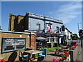
- Clicking on the map will re-center to the selected point.
- The higher the marker number, the further away the image location is from the centre of the postcode.
Image Listing (77 Images Found)
Images are licensed for reuse under creativecommons.org/licenses/by-sa/2.0
Image
Details
Distance
1
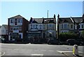
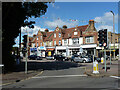
Businesses and houses on Portsmouth Road, Thames Ditton
Image: © JThomas
Taken: 29 Jul 2022
0.02 miles
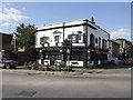
2
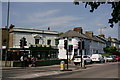
Long Ditton
Portsmouth Road, with 'The Ferry' public house to the left of picture.
Image: © Peter Trimming
Taken: 6 Jul 2018
0.02 miles
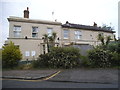
4
Wrythe Court on Portsmouth Road, Thames Ditton
Image: © David Howard
Taken: 25 Apr 2021
0.04 miles
5
Criterion Buildings, Portsmouth Road, Thames Ditton
Shops and flats.
Image: © Robin Webster
Taken: 26 Aug 2012
0.04 miles
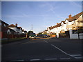
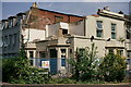
6
No longer a pub, Ewell Road
This only closed around a year ago from memory
Image: © David Howard
Taken: 28 May 2017
0.04 miles
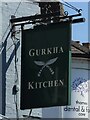
7
Long Ditton
Former public house, across the road from 'The Ferry'.
Image: © Peter Trimming
Taken: 6 Jul 2018
0.04 miles
9
The Ferry, Thames Ditton
On Portsmouth Road.
Image: © JThomas
Taken: 29 Jul 2022
0.05 miles
10
Ferry Tavern, Thames Ditton
The shutters aren't up yet but its future in doubt
Image: © al partington
Taken: 10 Sep 2007
0.05 miles