IMAGES TAKEN NEAR TO
Basing Way, THAMES DITTON, KT7 0NX
Introduction
This page details the photographs taken nearby to Basing Way, KT7 0NX by members of the Geograph project.
The Geograph project started in 2005 with the aim of publishing, organising and preserving representative images for every square kilometre of Great Britain, Ireland and the Isle of Man.

There are currently over 7.5m images from over14,400 individuals and you can help contribute to the project by visiting https://www.geograph.org.uk
Image Map
Images are licensed for reuse under creativecommons.org/licenses/by-sa/2.0
Notes
- Clicking on the map will re-center to the selected point.
- The higher the marker number, the further away the image location is from the centre of the postcode.
Image Listing (71 Images Found)
Images are licensed for reuse under creativecommons.org/licenses/by-sa/2.0
Image
Details
Distance

3
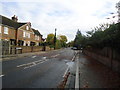
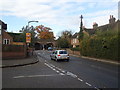
Basing Way, Thames Ditton
Basing Way, Thames Ditton, at its junction with Station Road.
Image: © Malc McDonald
Taken: 20 Jun 2010
0.09 miles
4
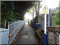
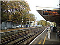
Footpath to Thames Ditton railway station
Image: © Stacey Harris
Taken: 6 Nov 2010
0.09 miles
8
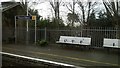
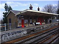
Thames Ditton station and gardens on Basingfield Road
Image: © Christopher Hilton
Taken: 10 Feb 2016
0.10 miles
9
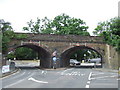
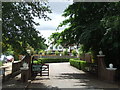
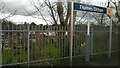
Railway arches, Thames Ditton
Arches over Station Road at Thames Ditton. The entrances to the station platforms are either side of the bridge, to the left just out of the picture.
Image: © Malc McDonald
Taken: 20 Jun 2010
0.11 miles