IMAGES TAKEN NEAR TO
Ditton Road, SURBITON, KT6 6RW
Introduction
This page details the photographs taken nearby to Ditton Road, KT6 6RW by members of the Geograph project.
The Geograph project started in 2005 with the aim of publishing, organising and preserving representative images for every square kilometre of Great Britain, Ireland and the Isle of Man.

There are currently over 7.5m images from over14,400 individuals and you can help contribute to the project by visiting https://www.geograph.org.uk
Image Map
Images are licensed for reuse under creativecommons.org/licenses/by-sa/2.0
Notes
- Clicking on the map will re-center to the selected point.
- The higher the marker number, the further away the image location is from the centre of the postcode.
Image Listing (6 Images Found)
Images are licensed for reuse under creativecommons.org/licenses/by-sa/2.0
Image
Details
Distance
1
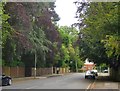
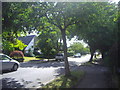
Langley Avenue (south-west portion)
Leafy suburbs don't come much leafier than this. The earliest properties here seem to date from the 1880's or 90's, and are not just substantial but huge, set well back from the street (and now screened from view by mature trees). Originally each had its own vast plot, making a later wave of development possible on portions that were hived off.
These days a number of the older properties in Langley Avenue have become nursing homes, while others have been subdivided.
Image: © Stefan Czapski
Taken: 30 May 2013
0.15 miles

6
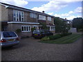
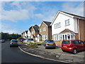
House on Love Lane, Long Ditton
The house has 5 bedrooms and is currently on the market for £850,000 in December 2011 as I discovered when checking the map location
Image: © David Howard
Taken: 5 Jul 2009
0.24 miles