IMAGES TAKEN NEAR TO
Ditton Grange Drive, SURBITON, KT6 5HG
Introduction
This page details the photographs taken nearby to Ditton Grange Drive, KT6 5HG by members of the Geograph project.
The Geograph project started in 2005 with the aim of publishing, organising and preserving representative images for every square kilometre of Great Britain, Ireland and the Isle of Man.

There are currently over 7.5m images from over14,400 individuals and you can help contribute to the project by visiting https://www.geograph.org.uk
Image Map
Images are licensed for reuse under creativecommons.org/licenses/by-sa/2.0
Notes
- Clicking on the map will re-center to the selected point.
- The higher the marker number, the further away the image location is from the centre of the postcode.
Image Listing (10 Images Found)
Images are licensed for reuse under creativecommons.org/licenses/by-sa/2.0
Image
Details
Distance
1
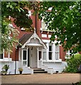
House entrance, Langley Avenue (1)
My guess is that this rather grand old house dates from within a few years of 1900. It owes a lot of its character to this porch, with its balusters and carved bargeboard.
While this property looks set to survive, elsewhere in the Surrey (and SW London) suburbs many large Victorian and Edwardian properties have been demolished to make way for smaller units - a trend which seemed to accelerate for a while early in the present century.
Image: © Stefan Czapski
Taken: 30 May 2013
0.16 miles
2
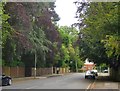
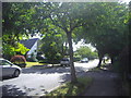
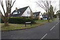
Langley Avenue (south-west portion)
Leafy suburbs don't come much leafier than this. The earliest properties here seem to date from the 1880's or 90's, and are not just substantial but huge, set well back from the street (and now screened from view by mature trees). Originally each had its own vast plot, making a later wave of development possible on portions that were hived off.
These days a number of the older properties in Langley Avenue have become nursing homes, while others have been subdivided.
Image: © Stefan Czapski
Taken: 30 May 2013
0.16 miles
4
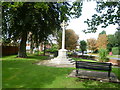
Long Ditton War Memorial
Long Ditton War Memorial is situated in a pleasant little garden at the junction of Ditton Hill and Church Lane, not far from St Mary's Church. The inscription on the base says: "THE MEN OF LONG DITTON WHOM THIS CROSS COMMEMORATES LEFT AT THE CALL OF KING AND COUNTRY ALL THAT WAS DEAR TO THEM, ENDURED HARDNESS, FACED DANGER AND FINALLY PASSED OUT OF THE SIGHT OF MEN BY THE PATH OF DUTY AND SELF-SACRIFICE, GIVING UP THEIR OWN LIVES THAT OTHERS MIGHT LIVE IN FREEDOM."
Image: © Marathon
Taken: 25 Sep 2013
0.21 miles
5
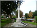
Long Ditton War Memorial
Long Ditton War Memorial is situated in a pleasant little garden at the junction of Ditton Hill and Church Lane, not far from St Mary's Church. The inscription on the base says: "THE MEN OF LONG DITTON WHOM THIS CROSS COMMEMORATES LEFT AT THE CALL OF KING AND COUNTRY ALL THAT WAS DEAR TO THEM, ENDURED HARDNESS, FACED DANGER AND FINALLY PASSED OUT OF THE SIGHT OF MEN BY THE PATH OF DUTY AND SELF-SACRIFICE, GIVING UP THEIR OWN LIVES THAT OTHERS MIGHT LIVE IN FREEDOM."
Image: © Marathon
Taken: 25 Sep 2013
0.21 miles
6
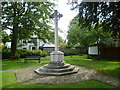
Long Ditton War Memorial in its garden
Long Ditton War Memorial is situated in a pleasant little garden at the junction of Ditton Hill and Church Lane, not far from St Mary's Church. The inscription on the base says: "THE MEN OF LONG DITTON WHOM THIS CROSS COMMEMORATES LEFT AT THE CALL OF KING AND COUNTRY ALL THAT WAS DEAR TO THEM, ENDURED HARDNESS, FACED DANGER AND FINALLY PASSED OUT OF THE SIGHT OF MEN BY THE PATH OF DUTY AND SELF-SACRIFICE, GIVING UP THEIR OWN LIVES THAT OTHERS MIGHT LIVE IN FREEDOM."
Image: © Marathon
Taken: 25 Sep 2013
0.21 miles
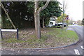
9
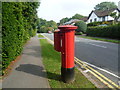
Lovelace Road, Surbiton
In 1834 an Act for building a railway between London and Southampton received Royal Assent. Local councillors in Kingston, coupled with the coaching interests and Lord Cottenham, owner of much of the land between Kingston and Wimbledon, objected to the railway running through the town, and so the railway was forced to pass a mile and a half to the south. A station opened in 1838 at what was then called “Kingston New Town” or, from 1841, “Kingston-on-Railway”. This was subsequently named Surbiton. The fine houses and good rail service attracted wealthy commuters and earned Surbiton the title of “Queen of the Suburbs”.
This is Lovelace Road which runs parallel to the railway line. Some of the fine houses along this road have been demolished and flats built on the sites.
Image: © Marathon
Taken: 25 Sep 2013
0.24 miles