IMAGES TAKEN NEAR TO
Love Lane, SURBITON, KT6 5EB
Introduction
This page details the photographs taken nearby to Love Lane, KT6 5EB by members of the Geograph project.
The Geograph project started in 2005 with the aim of publishing, organising and preserving representative images for every square kilometre of Great Britain, Ireland and the Isle of Man.

There are currently over 7.5m images from over14,400 individuals and you can help contribute to the project by visiting https://www.geograph.org.uk
Image Map
Images are licensed for reuse under creativecommons.org/licenses/by-sa/2.0
Notes
- Clicking on the map will re-center to the selected point.
- The higher the marker number, the further away the image location is from the centre of the postcode.
Image Listing (13 Images Found)
Images are licensed for reuse under creativecommons.org/licenses/by-sa/2.0
Image
Details
Distance
1
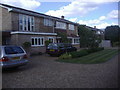
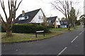
House on Love Lane, Long Ditton
The house has 5 bedrooms and is currently on the market for £850,000 in December 2011 as I discovered when checking the map location
Image: © David Howard
Taken: 5 Jul 2009
0.02 miles
2
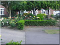
Rose gardens on Church Meadow, Long Ditton
Image: © David Howard
Taken: 5 Jul 2009
0.06 miles
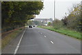
4
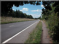
Road to Hook
Road from Hook to Hinchley Wood.
Image: © Dennis Turner
Taken: 21 Aug 2005
0.20 miles
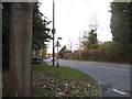
5
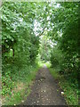
Love Lane
Love Lane is possibly an ancient trackway and runs between Woodstock Lane North and Southborough. This is close to the entrance in Woodstock Lane North.
Image: © Marathon
Taken: 25 Sep 2013
0.20 miles
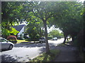
8
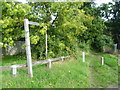
The entrance to Love Lane
Love Lane is possibly an ancient trackway and runs between Woodstock Lane North here and Southborough.
Image: © Marathon
Taken: 25 Sep 2013
0.23 miles
10
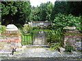
Entrance to the Garden of Rest, Long Ditton Churchyard
A church has stood on this hill since Saxon times. The Manor and church are included in the Domesday Book of 1086 and the earliest record of a Rector is Robert Picot appointed in 1166. The present St Mary's Church was built between 1878 and 1880 and replaced one built in 1776 in the form of a Greek cross.
The floor and part of the walls of this earlier church survive in the churchyard and are now laid out as the Garden of Rest, which is also the site of the churches before the one of 1776. This is the view of The Garden of Rest from the west.
Image: © Marathon
Taken: 25 Sep 2013
0.24 miles