IMAGES TAKEN NEAR TO
Victoria Avenue, SURBITON, KT6 5DL
Introduction
This page details the photographs taken nearby to Victoria Avenue, KT6 5DL by members of the Geograph project.
The Geograph project started in 2005 with the aim of publishing, organising and preserving representative images for every square kilometre of Great Britain, Ireland and the Isle of Man.

There are currently over 7.5m images from over14,400 individuals and you can help contribute to the project by visiting https://www.geograph.org.uk
Image Map
Images are licensed for reuse under creativecommons.org/licenses/by-sa/2.0
Notes
- Clicking on the map will re-center to the selected point.
- The higher the marker number, the further away the image location is from the centre of the postcode.
Image Listing (87 Images Found)
Images are licensed for reuse under creativecommons.org/licenses/by-sa/2.0
Image
Details
Distance
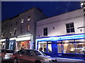
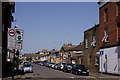
1
Excellar on the corner of Brighton Road and Victoria Road
Image: © David Howard
Taken: 6 Nov 2016
0.06 miles
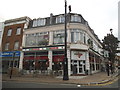
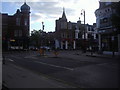
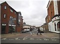
3
Surbiton
The YMCA, located at the end of Victoria Road.
Image: © Peter Trimming
Taken: 6 May 2018
0.07 miles
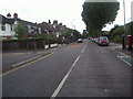
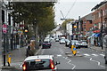
5
Victoria Road at the junction of Brighton Road, Surbiton
Image: © David Howard
Taken: 8 Jun 2013
0.07 miles
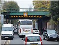
7
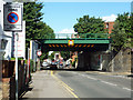
Railway Bridge over Brighton Road
Quite a new replacement steel structure, designed to carry five tracks.
Image: © Robin Webster
Taken: 26 Aug 2012
0.08 miles
9
Cottage Grove at the junction of Brighton Road
Image: © David Howard
Taken: 6 Nov 2016
0.08 miles