IMAGES TAKEN NEAR TO
Elmdene, SURBITON, KT5 9PW
Introduction
This page details the photographs taken nearby to Elmdene, KT5 9PW by members of the Geograph project.
The Geograph project started in 2005 with the aim of publishing, organising and preserving representative images for every square kilometre of Great Britain, Ireland and the Isle of Man.

There are currently over 7.5m images from over14,400 individuals and you can help contribute to the project by visiting https://www.geograph.org.uk
Image Map
Images are licensed for reuse under creativecommons.org/licenses/by-sa/2.0
Notes
- Clicking on the map will re-center to the selected point.
- The higher the marker number, the further away the image location is from the centre of the postcode.
Image Listing (40 Images Found)
Images are licensed for reuse under creativecommons.org/licenses/by-sa/2.0
Image
Details
Distance
1
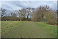
Knollmead
One of the tree lined streets on the inter war built Sunray housing development situated between the Waterloo and Chessington railway line and the A3 at Tolworth.
Image: © Dennis Turner
Taken: 28 Jun 2009
0.05 miles

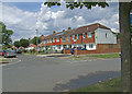
3

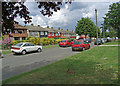
Elmdene
One of the tree lined streets on the inter war built Sunray housing development situated between the Waterloo and Chessington railway line and the A3 at Tolworth.
Image: © Dennis Turner
Taken: 28 Jun 2009
0.07 miles
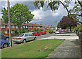
4
Knollmead
One of the tree lined streets on the inter war built Sunray housing development situated between the Waterloo and Chessington railway line and the A3 at Tolworth. The road joining Knollmead is Warren Drive South part of the same development.
Image: © Dennis Turner
Taken: 28 Jun 2009
0.07 miles
5
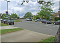
Southwood Drive
One of the tree lined streets on the inter war built Sunray housing development situated between the Waterloo and Chessington railway line and the A3 at Tolworth.
Image: © Dennis Turner
Taken: 28 Jun 2009
0.08 miles
6

Elmdene
One of the tree lined streets on the inter war built Sunray housing development situated between the Waterloo and Chessington railway line and the A3 at Tolworth.
Image: © Dennis Turner
Taken: 28 Jun 2009
0.10 miles
7
Knollmead
One of the tree lined streets on the inter war built Sunray housing development situated between the Waterloo and Chessington railway line and the A3 at Tolworth.
Image: © Dennis Turner
Taken: 28 Jun 2009
0.12 miles
8
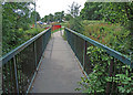
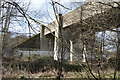
Hogsmill bridge
Footbridge crossing Hogsmill river between Sunray estate Tolworth and Malden Manor. View towards Sunray estate. The Thames Downs Link path also crosses the bridge at this point.
Image: © Dennis Turner
Taken: 28 Jun 2009
0.15 miles