IMAGES TAKEN NEAR TO
Sandringham Road, WORCESTER PARK, KT4 8XW
Introduction
This page details the photographs taken nearby to Sandringham Road, KT4 8XW by members of the Geograph project.
The Geograph project started in 2005 with the aim of publishing, organising and preserving representative images for every square kilometre of Great Britain, Ireland and the Isle of Man.

There are currently over 7.5m images from over14,400 individuals and you can help contribute to the project by visiting https://www.geograph.org.uk
Image Map
Images are licensed for reuse under creativecommons.org/licenses/by-sa/2.0
Notes
- Clicking on the map will re-center to the selected point.
- The higher the marker number, the further away the image location is from the centre of the postcode.
Image Listing (6 Images Found)
Images are licensed for reuse under creativecommons.org/licenses/by-sa/2.0
Image
Details
Distance
1
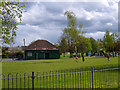
Cuddington Recreation Ground
A popular play area is to the right behind the trees.
Image: © Robin Webster
Taken: 10 Apr 2012
0.17 miles
3
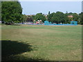
In Cuddington Recreation Ground
The name Cuddington almost vanished from the map when the medieval village, parish church and manor house were ruthlessly destroyed in 1538 to provide the site for Henry VIIIth to build his palace and home park at Nonsuch. The parish, which covers the area between Ewell and Cheam, including Nonsuch Park is still called Cuddington.
Cuddington Recreation Ground was once the fields and woods of Sparrow Farm, which still occupied the area early in the 20th century. The farmstead was situated towards the south-east end of the present-day park. Sparrow Farm Road to the south of the park commemorates the name.
The infant Beverley Brook passes under the grassland here in a culvert. The children's playground can be seen in the distance.
Image: © Marathon
Taken: 21 Aug 2013
0.20 miles
4
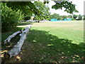
Cuddington Recreation Ground
The name Cuddington almost vanished from the map when the medieval village, parish church and manor house were ruthlessly destroyed in 1538 to provide the site for Henry VIIIth to build his palace and home park at Nonsuch. The parish, which covers the area between Ewell and Cheam, including Nonsuch Park is still called Cuddington.
Cuddington Recreation Ground was once the fields and woods of Sparrow Farm, which still occupied the area early in the 20th century. The farmstead was situated towards the south-east end of the present-day park. Sparrow Farm Road to the south of the park commemorates the name.
The infant Beverley Brook passes under the grassland here in a culvert. The children's playground can be seen in the distance.
Image: © Marathon
Taken: 21 Aug 2013
0.23 miles
5
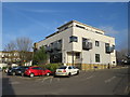
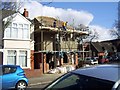
Modern apartment block in Worcester Park
A recently-built apartment block in Worcester Park, in the outer suburbs of sputh-west London.
The apartments look out over a supermarket car park.
Image: © Malc McDonald
Taken: 17 Feb 2019
0.24 miles
6
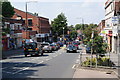
Central Road, Worcester Park
Looking down the hill towards the main shopping area.
Image: © Bill Boaden
Taken: 1 Aug 2011
0.24 miles