IMAGES TAKEN NEAR TO
Kingsmead Avenue, WORCESTER PARK, KT4 8XA
Introduction
This page details the photographs taken nearby to Kingsmead Avenue, KT4 8XA by members of the Geograph project.
The Geograph project started in 2005 with the aim of publishing, organising and preserving representative images for every square kilometre of Great Britain, Ireland and the Isle of Man.

There are currently over 7.5m images from over14,400 individuals and you can help contribute to the project by visiting https://www.geograph.org.uk
Image Map
Images are licensed for reuse under creativecommons.org/licenses/by-sa/2.0
Notes
- Clicking on the map will re-center to the selected point.
- The higher the marker number, the further away the image location is from the centre of the postcode.
Image Listing (13 Images Found)
Images are licensed for reuse under creativecommons.org/licenses/by-sa/2.0
Image
Details
Distance
3
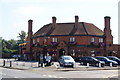
The H G Wells
A pub on Cheam Common Road to commemorate the author who lived for a while in Worcester Park.
Image: © Bill Boaden
Taken: 1 Aug 2011
0.11 miles
6
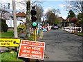
Road works on Dalmeny Road
The work seemed to be on the verges rather than the actual road.
Image: © Robin Webster
Taken: 10 Apr 2012
0.16 miles
7
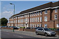
Office block on Cheam Common Road
This building is occupied by commercial offices but it looks like it should have been a school.
Image: © Bill Boaden
Taken: 1 Aug 2011
0.17 miles
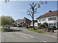
8
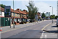
Cheam Common Road
Approaching its junction with the A24 London Road.
Image: © Bill Boaden
Taken: 1 Aug 2011
0.20 miles
9
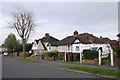
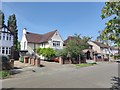
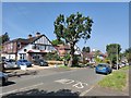
Houses on St Clair Drive
These semi-detached houses and semi-detached bungalows which date from the 1930's are on St Clair Drive close to its junction with Dalmeny Rd and Sandringham Rd which can be seen on the extreme left of the image.
Image: © Nigel Mykura
Taken: 17 Apr 2015
0.21 miles
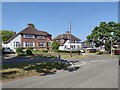
10
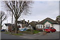
Houses on St Clair Drive
These bungalows and detached houses are typical of the 1930's houses that blanket cover much of this area of south London.
Image: © Nigel Mykura
Taken: 17 Apr 2015
0.22 miles