IMAGES TAKEN NEAR TO
Riverhill Gardens, WORCESTER PARK, KT4 7QB
Introduction
This page details the photographs taken nearby to Riverhill Gardens, KT4 7QB by members of the Geograph project.
The Geograph project started in 2005 with the aim of publishing, organising and preserving representative images for every square kilometre of Great Britain, Ireland and the Isle of Man.

There are currently over 7.5m images from over14,400 individuals and you can help contribute to the project by visiting https://www.geograph.org.uk
Image Map
Images are licensed for reuse under creativecommons.org/licenses/by-sa/2.0
Notes
- Clicking on the map will re-center to the selected point.
- The higher the marker number, the further away the image location is from the centre of the postcode.
Image Listing (21 Images Found)
Images are licensed for reuse under creativecommons.org/licenses/by-sa/2.0
Image
Details
Distance
1
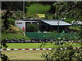
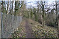
Surbiton Raceway
Go-karting track on the banks of the Hogsmill River, between Ewell and Tolworth.
http://www.epsomandewellhistoryexplorer.org.uk/Hogsmill.html
Image: © Colin Smith
Taken: 3 Jul 2012
0.13 miles
2
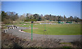
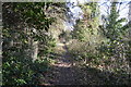
Tolworth Karting Circuit
Go Kart facility beside the London Loop Path.
Image: © Des Blenkinsopp
Taken: 26 Mar 2012
0.18 miles
3
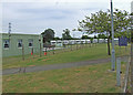
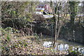
Social club
Sunray Residents Association social club south of Knollmead railway bridge.
Image: © Dennis Turner
Taken: 28 Jun 2009
0.18 miles
10
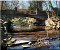
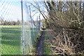
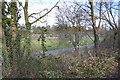
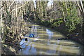
Low Flow in the Hogsmill
March 2012. Recent dry weather has caused unseasonally low flows in many rivers.
This bridge takes the London Loop path over the Hogsmill.
London borough of Kingston upon Thames on the right, Surrey borough of Epsom and Ewell on the left.
Image: © Des Blenkinsopp
Taken: 26 Mar 2012
0.21 miles