IMAGES TAKEN NEAR TO
The Manor Drive, WORCESTER PARK, KT4 7LN
Introduction
This page details the photographs taken nearby to The Manor Drive, KT4 7LN by members of the Geograph project.
The Geograph project started in 2005 with the aim of publishing, organising and preserving representative images for every square kilometre of Great Britain, Ireland and the Isle of Man.

There are currently over 7.5m images from over14,400 individuals and you can help contribute to the project by visiting https://www.geograph.org.uk
Image Map
Images are licensed for reuse under creativecommons.org/licenses/by-sa/2.0
Notes
- Clicking on the map will re-center to the selected point.
- The higher the marker number, the further away the image location is from the centre of the postcode.
Image Listing (62 Images Found)
Images are licensed for reuse under creativecommons.org/licenses/by-sa/2.0
Image
Details
Distance
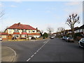
1
Tamesis Gardens, Worcester Park
Tamesis Gardens is a modern housing development in Worcester Park, on the outer fringe of south west London. "Tamesis" is the Latin name for "Thames".
Image: © Malc McDonald
Taken: 17 Feb 2019
0.14 miles
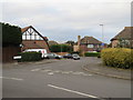
2
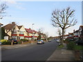
Highdown, Worcester Park
Highdown in Worcester Park, in the outer suburbs of south west London. This image was taken at the junction with Lady Hay, another minor residential road.
Image: © Malc McDonald
Taken: 17 Feb 2019
0.15 miles
3
Barrow Hill - Steep Hill 16%
Barrow Hill, Worcester Park. 16% steep hill down sign.
Image: © Adam Morse
Taken: 10 Aug 2009
0.17 miles
4
Highdown, Worcester Park
Highdown is a residential road in south west London's outer suburbs.
Image: © Malc McDonald
Taken: 17 Feb 2019
0.17 miles
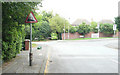
5
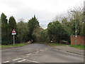
Barrow Hill, near Worcester Park
This image was taken right on the boundary of Greater London and Surrey.
The London Loop long-distance path passes through the gap between the tree and the brick wall.
Image: © Malc McDonald
Taken: 17 Feb 2019
0.18 miles
6
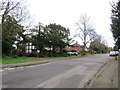
Royal Avenue, near Worcester Park
Royal Avenue is a residential road in Surrey, bordering on Greater London.
Image: © Malc McDonald
Taken: 17 Feb 2019
0.18 miles
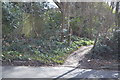
7
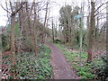
London LOOP near Old Malden
A footpath through woodland near Old Malden, on the outer fringe of south west London. The path forms part of the London LOOP long-distance path.
Image: © Malc McDonald
Taken: 17 Feb 2019
0.19 miles
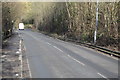
9
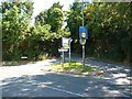
Old Malden: Barrow Hill
Seen from its junction with Old Malden Lane, (B284). This short, steep and narrow hill is often used by rat-running motorists from the Worcester Park area seeking access onto the westbound A3.
Image: © Dr Neil Clifton
Taken: 19 Jul 2013
0.20 miles