IMAGES TAKEN NEAR TO
Gunpowder Road, KT4 7BF
Introduction
This page details the photographs taken nearby to Gunpowder Road, KT4 7BF by members of the Geograph project.
The Geograph project started in 2005 with the aim of publishing, organising and preserving representative images for every square kilometre of Great Britain, Ireland and the Isle of Man.

There are currently over 7.5m images from over14,400 individuals and you can help contribute to the project by visiting https://www.geograph.org.uk
Image Map
Images are licensed for reuse under creativecommons.org/licenses/by-sa/2.0
Notes
- Clicking on the map will re-center to the selected point.
- The higher the marker number, the further away the image location is from the centre of the postcode.
Image Listing (40 Images Found)
Images are licensed for reuse under creativecommons.org/licenses/by-sa/2.0
Image
Details
Distance
6
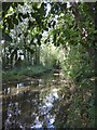
The Hogsmill River: view upstream
Flow is so sluggish along this stretch that I had to check with the map to determine which way was upstream and which down.
Image: © Stefan Czapski
Taken: 5 Oct 2017
0.06 miles
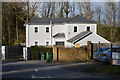
8
Hogsmill, Pub & Carvery
Large and popular pub / restaurant in Ewell, adjacent to the Hogsmill River.
Image: © Colin Smith
Taken: 3 Jul 2012
0.09 miles
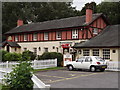
9
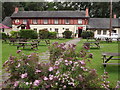
Hogsmill Beer Garden
Chain pub / restaurant in Ewell with a fine big open space at the front.
Image: © Colin Smith
Taken: 3 Jul 2012
0.09 miles
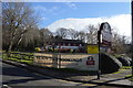
10
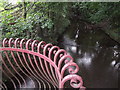
Hogsmill River
View of this Thames tributary from the bridge opposite the Hogsmill Tavern, Ewell.
http://www.epsomandewellhistoryexplorer.org.uk/Hogsmill.html
Image: © Colin Smith
Taken: 3 Jul 2012
0.09 miles