IMAGES TAKEN NEAR TO
Northcote Road, LEATHERHEAD, KT24 6LT
Introduction
This page details the photographs taken nearby to Northcote Road, KT24 6LT by members of the Geograph project.
The Geograph project started in 2005 with the aim of publishing, organising and preserving representative images for every square kilometre of Great Britain, Ireland and the Isle of Man.

There are currently over 7.5m images from over14,400 individuals and you can help contribute to the project by visiting https://www.geograph.org.uk
Image Map
Images are licensed for reuse under creativecommons.org/licenses/by-sa/2.0
Notes
- Clicking on the map will re-center to the selected point.
- The higher the marker number, the further away the image location is from the centre of the postcode.
Image Listing (6 Images Found)
Images are licensed for reuse under creativecommons.org/licenses/by-sa/2.0
Image
Details
Distance
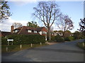
1
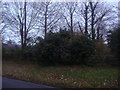
Woodland by East Lane, West Horsley
The first house on this side of the road can just be seen on the left.
Image: © David Howard
Taken: 12 Dec 2011
0.09 miles
2
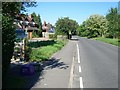
East Lane, West Horsley
looking north-east
Image: © Andrew Longton
Taken: 8 Sep 2005
0.10 miles
3
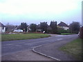
East Lane, West Horsley
The four conifers have recently been cut down by half, they originally ended in points as nature intended.
Image: © David Howard
Taken: 12 Dec 2011
0.16 miles
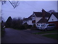
6
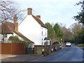
Waterloo Farm Cottage
East Lane in West Horsley has no pavement where the road passes this old cottage.
Image: © Colin Smith
Taken: 11 Jan 2009
0.24 miles