IMAGES TAKEN NEAR TO
Ripley Lane, LEATHERHEAD, KT24 6JT
Introduction
This page details the photographs taken nearby to Ripley Lane, KT24 6JT by members of the Geograph project.
The Geograph project started in 2005 with the aim of publishing, organising and preserving representative images for every square kilometre of Great Britain, Ireland and the Isle of Man.

There are currently over 7.5m images from over14,400 individuals and you can help contribute to the project by visiting https://www.geograph.org.uk
Image Map
Images are licensed for reuse under creativecommons.org/licenses/by-sa/2.0
Notes
- Clicking on the map will re-center to the selected point.
- The higher the marker number, the further away the image location is from the centre of the postcode.
Image Listing (18 Images Found)
Images are licensed for reuse under creativecommons.org/licenses/by-sa/2.0
Image
Details
Distance
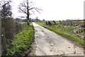
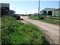
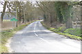
2
Byway reaches Ripley Lane and continues as a bridleway
Image: © Shazz
Taken: 12 Mar 2015
0.02 miles
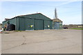
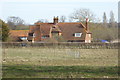
4
Jury Farm
Looking west along the bridleway through the farmyard.
Image: © Andrew Longton
Taken: 8 Sep 2005
0.08 miles
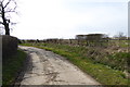
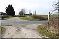
8
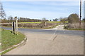
Bridleway reaches Ripley Lane and continues as a byway
Image: © Shazz
Taken: 12 Mar 2015
0.15 miles