IMAGES TAKEN NEAR TO
Ripley Lane, LEATHERHEAD, KT24 6JP
Introduction
This page details the photographs taken nearby to Ripley Lane, KT24 6JP by members of the Geograph project.
The Geograph project started in 2005 with the aim of publishing, organising and preserving representative images for every square kilometre of Great Britain, Ireland and the Isle of Man.

There are currently over 7.5m images from over14,400 individuals and you can help contribute to the project by visiting https://www.geograph.org.uk
Image Map
Images are licensed for reuse under creativecommons.org/licenses/by-sa/2.0
Notes
- Clicking on the map will re-center to the selected point.
- The higher the marker number, the further away the image location is from the centre of the postcode.
Image Listing (15 Images Found)
Images are licensed for reuse under creativecommons.org/licenses/by-sa/2.0
Image
Details
Distance
1
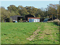
Lower Hammond's Farm
The farm buildings from the footpath from Ripley Road that runs alongside the railway.
Image: © Alan Hunt
Taken: 28 Oct 2014
0.01 miles
2
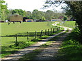
West Horsley - Lower Hammond's Farm
Access across paddocks to "glamping field" in Hatchlands Park.
Image: © Colin Smith
Taken: 26 Apr 2022
0.05 miles
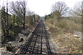
3
Railway bridge over Ripley Lane, West Horsley
Looking south.
Image: © Andrew Longton
Taken: 8 Sep 2005
0.06 miles
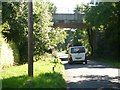
5
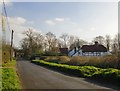
Ripley Lane, approaching West Horsley from the north
Looking south towards the railway bridge which carries the Effingham Junction-Guildford line. The house is fairly typical of older houses in the area - timber framed with brick 'nogging'.
Photo taken from the entrance to Horsley and Send Cricket Club.
Image: © Stefan Czapski
Taken: 6 Apr 2015
0.07 miles
6
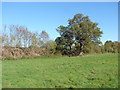
Tree by the tracks
Trees beside the Guildford to Leatherhead line near Lower Hammond's Farm.
Image: © Alan Hunt
Taken: 28 Oct 2014
0.09 miles
8
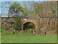
Railway bridge near Lower Hammond's Farm
The railway bridge over a drain near Lower Hammond's Farm.
Image: © Alan Hunt
Taken: 28 Oct 2014
0.16 miles
9
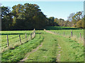
Path towards Hatchlands Park
The footpath from Lower Hammond's Farm past the northern end of hatchlands Park marked by the trees to Ripley Road.
Image: © Alan Hunt
Taken: 28 Oct 2014
0.17 miles
10
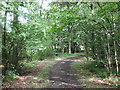
Bend in the Long Walk
At the northern tip of the Long Walk the path returns south towards Hatchlands.
Image: © don cload
Taken: 4 Aug 2011
0.17 miles