IMAGES TAKEN NEAR TO
Shere Road, LEATHERHEAD, KT24 6ET
Introduction
This page details the photographs taken nearby to Shere Road, KT24 6ET by members of the Geograph project.
The Geograph project started in 2005 with the aim of publishing, organising and preserving representative images for every square kilometre of Great Britain, Ireland and the Isle of Man.

There are currently over 7.5m images from over14,400 individuals and you can help contribute to the project by visiting https://www.geograph.org.uk
Image Map
Images are licensed for reuse under creativecommons.org/licenses/by-sa/2.0
Notes
- Clicking on the map will re-center to the selected point.
- The higher the marker number, the further away the image location is from the centre of the postcode.
Image Listing (10 Images Found)
Images are licensed for reuse under creativecommons.org/licenses/by-sa/2.0
Image
Details
Distance
1
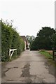
Hookwood Farm
Hookwood Farm, seen from Fullers Farm Road. The private access road ahead is also public bridleway West Horsley 89 to Shere Road at Hillside Farm. The buildings at Hookwood Farm are divided up into a number of separate dwellings: visible on the left are Hookwood House and Sweet Briar Cottage.
Image: © Hugh Craddock
Taken: 28 Sep 2013
0.01 miles
2
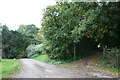
Fullers Farm Road at Hookwood Farm
Fullers Farm Road leading down to Shere Road. To the right is public bridleway West Horsley 89 to Francis Corner on Combe Lane.
Image: © Hugh Craddock
Taken: 28 Sep 2013
0.05 miles
3
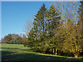
Small copse, Woodcote Farm
A small copse on the edge of one of the fields of Woodcote Farm.
Image: © Alan Hunt
Taken: 18 Nov 2014
0.09 miles
4
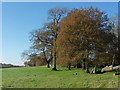
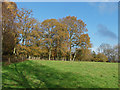
Oaks, Woodcote Farm
Oak trees along the edge of one of the fields of Woodcote Farm.
Image: © Alan Hunt
Taken: 18 Nov 2014
0.13 miles
5
Bridleway to Hookwood Manor
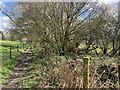
Bridleway West Horsley 89 to Fullers Farm Road at Hookwood Manor. The bridleway here follows the parish boundary between West Horsley and Shere — the latter an immense parish stretching from Winterfold Forest to the North Downs.
Image: © Hugh Craddock
Taken: 24 Mar 2024
0.16 miles
6
Oak trees, Woodcote Farm
A line of oaks in their autumn colours around the edge of one of the apddocks of Woodcote Farm.
Image: © Alan Hunt
Taken: 18 Nov 2014
0.17 miles
7
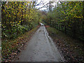
Fuller's Lane
The access road leading to Fuller's Farm from the Shere Road past Woodcote Farm.
Image: © Alan Hunt
Taken: 18 Nov 2014
0.20 miles
8
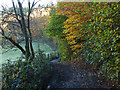
Steep footpath near Fuller's Farm
The footpath from Fuller's Farm to Blake's Lane on the backslope of the North Downs.
Image: © Alan Hunt
Taken: 18 Nov 2014
0.23 miles
9
Footpath near Fuller's Farm
The path from Fuller's Farm to Blake's Lane nearWoolgar's Farm. The path drops down the backslope of the North Downs from a high point near Woodcote Farm.
Image: © Alan Hunt
Taken: 18 Nov 2014
0.23 miles
10
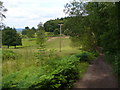
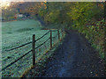
Byway to Hook Wood
Wide track on the dip slope of the North Downs. The area ahead is used for rearing horses, pony-trekking, etc.
Image: © Colin Smith
Taken: 14 Jul 2007
0.24 miles