IMAGES TAKEN NEAR TO
Shere Road, LEATHERHEAD, KT24 6EJ
Introduction
This page details the photographs taken nearby to Shere Road, KT24 6EJ by members of the Geograph project.
The Geograph project started in 2005 with the aim of publishing, organising and preserving representative images for every square kilometre of Great Britain, Ireland and the Isle of Man.

There are currently over 7.5m images from over14,400 individuals and you can help contribute to the project by visiting https://www.geograph.org.uk
Image Map
Images are licensed for reuse under creativecommons.org/licenses/by-sa/2.0
Notes
- Clicking on the map will re-center to the selected point.
- The higher the marker number, the further away the image location is from the centre of the postcode.
Image Listing (36 Images Found)
Images are licensed for reuse under creativecommons.org/licenses/by-sa/2.0
Image
Details
Distance
1
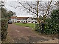
Large House on Unnamed Road
Minor Cul-de-sac of Shere Road.
Image: © James Emmans
Taken: 13 Jan 2019
0.03 miles
2
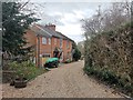
Victorian Red Brick cottage with Developments
Nicely upgraded access road to a few properties.
Image: © James Emmans
Taken: 13 Jan 2019
0.05 miles
3
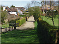
Footpath from Daws Dene
The footpath from Daws Dene runs along an access road off Shere Road at its northern end.
Image: © Alan Hunt
Taken: 12 Apr 2015
0.09 miles
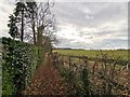
4
Access road off Shere Road
An access road off the Shere Road south of West Horsley. Four grid squares appear in this photograph.
Image: © Alan Hunt
Taken: 12 Apr 2015
0.09 miles
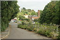
5
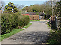
Jefferies Road
A private road giving access out of Shere Road to about half a dozen houses ranged along the north side of the road, and with a communal garden on the south side (the whole being managed by a residents' management company). The west end of the road forms a tee onto West Horsley public footpath 88.
Image: © Hugh Craddock
Taken: 28 Sep 2013
0.09 miles
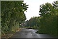
6
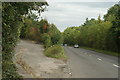
A246 at West Horsley, Surrey
The old A246 lies to the left. Some time during the 1960's, the "new" road to the right was built.
Image: © Peter Trimming
Taken: 17 Sep 2009
0.11 miles
7
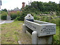
Old Cattle Trough, West Horsley.
On the Epsom Road roundabout, and redolent of days when horses were commonly used for transport. The stone trough carries inscriptions - "Metropolitan Drinking Fountain and Cattle Trough Association" and "Erected Under the Will of Mrs Laura M. Fielder of West Horsley Place". Behind is a brick waterworks building.
Image: © Colin Smith
Taken: 14 Jul 2007
0.11 miles
9
Old Epsom Road
This is a remnant of the old Epsom Road, the former Leatherhead to Guildford turnpike, which was replaced by a flatter alignment slightly to the south in the late 1960s. The old road remains accessible at both ends, but services only the entrance to Hatch Field House and a footpath cutting off the corner to West Horsley Street. The west end is also used by the council for storing road making materials. See Image and Image for either end.
Image: © Hugh Craddock
Taken: 28 Sep 2013
0.12 miles
10
The "old" A246 at West Horsley, Surrey
At some time in the 1960's, the "new" road was built to by-pass this narrow section (to the right, and below the old road level). At that time, the distant roundabout was built. Prior to this, my recollection was of traffic lights controlling the flow of traffic both across the A246, and through this narrow section, which was only wide enough to accommodate a single flow of traffic.
Image: © Peter Trimming
Taken: 17 Sep 2009
0.13 miles